CHORUS
EO
Ocean
Land
Snow & Ice
CHORUS is a two-satellite radar constellation of MDA Ltd. (MacDonald, Dettwiler and Associates Ltd.). The mission will use tipping and cueing techniques, as well as near-real time data exploitation aided by machine-learning and artificial intelligence, to deliver products for a variety of maritime and land-based applications.
Quick facts
Overview
| Mission type | EO |
| Agency | MDA |
| Mission status | Planned |
| Measurement domain | Ocean, Land, Snow & Ice |
| Instruments | X-SAR, C-SAR |
| Instrument type | Imaging microwave radars |
Related Resources
Summary
Mission Capabilities
The constellation comprises CHORUS C, carrying a C-band synthetic aperture radar (SAR), and CHORUS X, carrying an X-band SAR. CHORUS C will be developed by MDA using RADARSAT heritage, while ICEYE will develop CHORUS X, with the design based on the 3rd generation ICEYE satellite. The satellites will both follow the same ground track.
The two satellites will work together to maximise the information obtained by the constellation. CHORUS C will first pass over an area, and downlink the low-resolution data in real time to the ground station. This low-resolution data is analysed by AI/ML software to identify any objects of interest. When CHORUS X comes into view about 55 minutes later, the ground station uplinks the coordinates of the object of interest to CHORUS X. The X-band radar can then provide a high resolution image of the object of interest, 60 minutes after the object was identified by CHORUS C.
Performance Specifications
CHORUS will be able to image at a maximum swath width of 700 km with CHORUS C, and a highest resolution of 0.25 m with the Spotlight mode on CHORUS X.
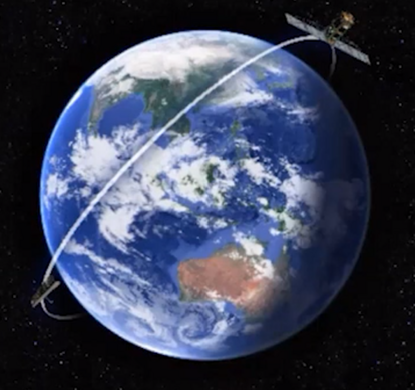
Both CHORUS satellites will be placed into the same orbit, with CHORUS X trailing CHORUS C by 60 minutes. The orbit will be an inclined, non-sun-synchronous orbit, at an altitude of approximately 600 km and inclination of 53.5°. The imaging time will shift earlier by about 20 minutes per day, allowing CHORUS to view the same region at different times of the day.
Space and Hardware Components
CHORUS C will be designed, built, owned and operated by MDA Ltd, and will combine the best elements of RADARSAT-2 and the RADARSAT Continuity Mission (RCM) along with new improvements and innovations. Meanwhile, CHORUS X will be based on the ICEYE 3rd generation design, with modifications for CHORUS.
CHORUS will utilise the ground segment of the RADARSAT missions, using the MDA headquarters, RGS (RADARSAT Ground Segment) and the cloud for direct downlink. CHORUS C will have a downlink rate of 2 x 300 Mbit/s, while CHORUS X will have a rate greater than 500 Mbit/s.
Overview
CHORUS is the next generation radar satellite from MDA Ltd. (MacDonald, Dettwiler and Associates Ltd.), building on the RADARSAT program. CHORUS will include C-band and X-band SAR satellites operating in a unique mid-inclination orbit with day or night imaging in all weather conditions. 1)
The name CHORUS comes from the mission objective to bring together multiple diverse and unique perspectives in harmony, to provide a new level of real-time insight about our planet. CHORUS builds on the strong heritage of the RADARSAT program and brings forward innovative new technologies and operations concepts to deliver a significantly enhanced capability.
The powerful C-band SAR satellite (CHORUS C) will provide broad area coverage in concert with a smaller trailing X-band SAR satellite (CHORUS X) for higher resolution data collection and Near Real-Time (NRT) cross-cueing day or night and in all weather conditions. CHORUS X will fly in the same mid-inclination orbit with the identical ground track as the MDA-built CHORUS C.
By collecting and integrating data from the individual satellites, CHORUS will provide the most extensive radar imaging capacity available on the market in one system, ranging from industry leading broad area coverage with a 700 km-wide swath to sub-meter very high resolution spotlight images.
In keeping with RADARSAT heritage, CHORUS will showcase unique capability for maritime surveillance and other time-critical applications, such as land intelligence and disaster response. This near-real time (NRT) capability will be enabled through fast-tasking for tactical operations and direct downlinks to a global network of cloud-enabled ground stations.
With core C-band and X-band sensors operating in a unique mid-inclination orbit, CHORUS will support higher imaging frequency between the mid-latitude areas of the northern and southern hemispheres. With tipping and cueing techniques, higher imaging performance, more imaging time per orbit, fast-tasking, faster delivery timelines and NRT data exploitation aided by machine-learning and artificial intelligence, CHORUS will offer advanced, innovative and disruptive Earth observation services, including:
- protection of national security and sovereignty by providing critical time sensitive data and intelligence on maritime and land activities;
- detection of illegal activities such as overfishing, deforestation, or bilge water dumping;
- monitoring of crops, critical infrastructure, transportation corridors, coastal erosion and the effects of climate change;
- provision of timely information to support humanitarian aid disaster response in response to floods, earthquakes, hurricanes, volcanoes and marine oil spills; and
- routine systematic observations for a variety of applications natural resources, industrial and geographic applications including agriculture, forestry, mining and exploration activities.
The mission has a design life of 15 years, with CHORUS C expected to remain in operation for the full limetime. However, it is expected that multiple versions of the CHORUS X satellite will need to be launched to sustain the full 15 years. 5)
Maritime Applications
The two CHORUS satellites will work together to help identify and track maritime vessels. The concept allows for CHORUS C to first pass over an area, and downlink the data in real time to the ground station. This low-resolution data is analysed by AI/ML software to identify any vessels of interest. When CHORUS X comes into view about 55 minutes later, the ground station uplinks the coordinates of the vessel of interest to CHORUS X. The X-band radar can then provide a high resolution image of the vessel of interest, 60 minutes after the vessel was identified by CHORUS C. 5)
This concept can also be applied for oil spills, as well as other land-based applications.
Spacecraft
The CHORUS mission is composed of two satellites, CHORUS C and CHORUS X. The details for both are shown in Table 1. CHORUS C will carry a C-band SAR instrument, while CHORUS X will carry an X-band SAR instrument. 5)
Characteristic | CHORUS C | CHORUS X |
Total launch mass | 2,200 kg | 115 kg |
Maximum swath width | 700 km | 100 km |
Orbit Altitude | 588-602 km | 588-602 km |
Orbit Inclination | 53.5 degrees | 53.5 degrees |
Descending/Ascending node | Varied (changes by about 20 minutes per day) | Varied (changes by about 20 minutes per day) |
Repeat cycle | 9.85 days | 9.85 days |
SAR antenna area | 18.5 m2 | 1.3m2 |
SAR Aperture | Dual | Single |
Solar power generation | 5700 W | TBD |
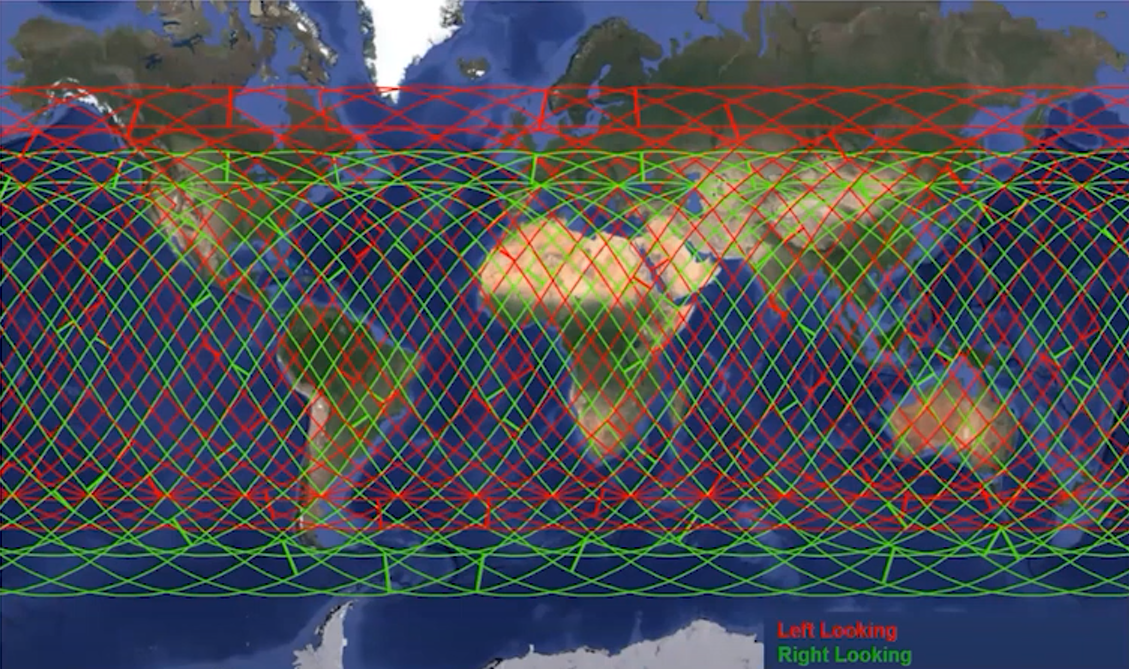
Look direction | Right & left | Right & left |
Polarisation | HH, VV, HV, VH & Compact Pol | VV |
Delivery Timeline | < 30 min | < 30 min |
Tasking Timeline | < 1 hour | < 1 hour |
Change detection | InSAR & ACD | InSAR & ACD |
Downlink | 2 x 300 Mbit/s | > 500 Mbit/s |
The inclined orbit of CHORUS will allow for greater coverage over equatorial regions when compared to a polar orbit (such as that of RADARSAT). However, the mission will not be able to image outside of ±62.5°. Using the mission’s left & right looking modes, CHORUS will be able to maximise accessible area, coverage and revisit times. MDA anticipates it will switch the look direction about 15-20 times per day. 5)
MDA has identified a ‘Canadian Core Area of Interest’ (AOI) of 11.5M km2. When running simulations over a nine day period, CHORUS covered on average 92.6% of the AOI with 8.6 average passes during 24 hours. For comparison, RADARSAT-2 can obtain a 48.8% average coverage of the AOI each day. 5)
The North American Ice Service tracks the location of icebergs in the North Atlantic, using ships, aircraft and satellites. They produce daily maps which show the southern extent of icebergs, identifying safe regions for maritime vessels. A simulation showed that, using the WideFine mode with 8m resolution, CHORUS could cover 63% of the area around the ice limit border. Meanwhile, RADARSAT-2 could only cover 23% over the identified area. 5)
Orbit
CHORUS will orbit in a low Earth orbit, at an altitude of approximately 588-602 km and an inclination of 53.5°. The orbit will be non-sun-synchronous, unlike previous RADARSAT missions, with the imaging time becoming about 20 minutes earlier each day.
Mission Status
- December 15, 2021: MDA and ICEYE have entered into an agreement for ICEYE to supply an X-band Synthetic Aperture Radar (SAR) spacecraft for CHORUS. The companies also announced that they have signed a separate distribution agreement that will allow MDA to sell ICEYE’s existing and future X-band data to select RADARSAT-2 customers as well as to develop value-added products to immediately take advantage of advanced information data integration and analytics from these two types of SAR sensors. 4)
- February 9, 2022: Magellan Aerospace Corporation of Toronto, Canada, has been awarded a contract award from MDA Ltd. to provide spacecraft avionics for their next Earth observation mission named CHORUS. The avionics subsystems for CHORUS will be developed at Magellan’s Winnipeg facility, home of western Canada’s Advanced Satellite Integration Facility. Magellan will be responsible for the design, manufacture, test, and delivery of the bus avionics system for the C-band SAR satellite. The bus avionics include the satellite bus power control and distribution, communications, attitude control, orbit determination, and on-board telemetry data collection. Key avionics deliverables include Magellan's Power Control Unit and Command and Data Handling Unit. 3)
- April 27, 2022: OHB Sweden has been contracted by MDA Ltd., a leading provider of advanced technology and services to the rapidly-expanding global space industry, to design, manufacture, integrate, test, and deliver the reaction control subsystem for its recently announced CHORUS commercial Earth observation constellation. The on-board propulsion system will be used to correct any launch vehicle injection errors and perform station keeping, collision avoidance manoeuvres and spacecraft de-orbiting at the end of the mission. 2)
Sensor Complement
Both the C-band and X-band SAR instruments on-board CHORUS C and CHORUS X respectively will be able to operate in a number of modes, including ScanSAR, Vessel Detection (single azimuth look), Stripmap and Spotlight.
CHORUS C will be designed, built, owned and operated by MDA Ltd, and will combine the best elements of RADARSAT-2 and the RADARSAT Continuity Mission (RCM) along with new improvements and innovations. Meanwhile, CHORUS X will be based on the ICEYE 3rd generation design, with modifications for CHORUS.
Details of the modes and their swaths can be found in Table 2.
Mode | Swath Width | Resolution |
ScanSAR | 700 km | 140 m |
ScanSAR | 500 km | 100 m |
ScanSAR | 250 km | 50 m |
Detection of Vessels Wide | 500 km | N/A |
Detection of Vessels Wide | 450 km | N/A |
Detection of Vessels Narrow | 250 km | N/A |
Stripmap | 180 km | 8 m |
Stripmap | 180 km | 5 m |
Stripmap | 100 km | 5 m |
Stripmap | 50 km | 3 m |
Spotlight | 5 km | 0.25 m in Azimuth and 0.5m in range |
Ground Segment
CHORUS will utilise the ground segment of the RADARSAT missions, using the MDA headquarters, RGS (RADARSAT Ground Segment) and the cloud for direct downlink. CHORUS C will have a downlink rate of 2 x 300 Mbit/s, while CHORUS X will have a rate greater than 500 Mbit/s.
The next generation collection capabilities relies on Machine Learning and AI for board area collection and downlink, as well as the near-real time exploitation of the Cross Cue from CHORUS C to CHORUS X.
References
1) ”MDA announces CHORUS™ as the name of its next market-leading commercial Earth Observation mission,” MDA News Release, 14 December 2021, URL: https://mda.space/en/article/mda-announces-chorus-name-of-its-commercial-earth-observation-mission/
2) ”OHB Sweden joins the CHORUS,” OHB Sweden, 27 April 2022, URL: https://www.ohb-sweden.se/news-and-media/ohb-sweden-joins-the-chorus
3) ”Magellan Aerospace to Provide Satellite Avionics Subsystems for CHORUS, MDA’s Next Generation Commercial Earth Observation Mission,” Businesswire, 9 February 2022, URL: https://www.businesswire.com/news/home/20220209005142/en/Magellan-Aerospace-to-Provide-Satellite-Avionics-Subsystems-for-CHORUS-MDA%E2%80%99s-Next-Generation-Commercial-Earth-Observation-Mission
4) ”MDA and ICEYE Sign Agreement To Integrate X-Band SAR Satellite Into MDA’s CHORUS™ Constellation,” MDA News Release, 15 December 2021, URL: https://mda.space/en/article/mda-and-iceye-sign-agreement-CHORUS-constellation-x-band-sar-satellite/
5) “CHORUS - Changing How and When We See the World”, GeoIgnite "Winter Geo" Canada's National Geospatial Conference 2022, 1 March 2022. URL: https://www.youtube.com/watch?v=oLyqayCcp20