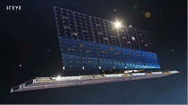
ICEYE Microsatellites Constellation
EO
Land
Multi-purpose imagery (land)
Land surface imagery
The ICEYE constellation is a constellation of X-band SAR Satellites. The ICEYE satellites provide high-resolution images the Earth’s surface to enable better decision making based on the Earth observation data.
Quick facts
Overview
| Mission type | EO |
| Agency | ICEYE |
| Mission status | Operational (nominal) |
| Launch date | 03 Dec 2018 |
| Measurement domain | Land |
| Measurement category | Multi-purpose imagery (land) |
| Measurement detailed | Land surface imagery |
| Instruments | X-Band SAR |
| Instrument type | Imaging microwave radars |
| CEOS EO Handbook | See ICEYE Microsatellites Constellation summary |
Related Resources
Summary
Mission Capabilities
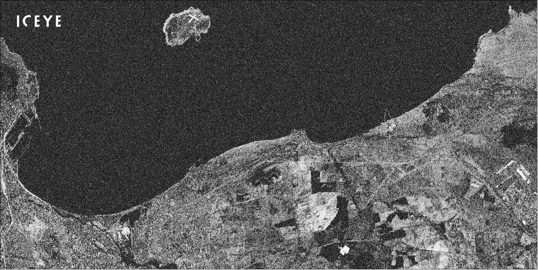
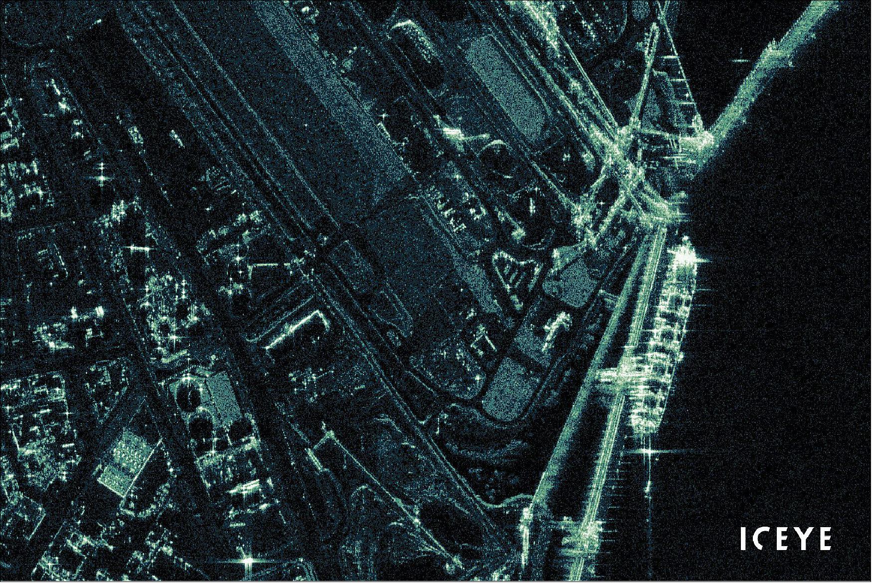
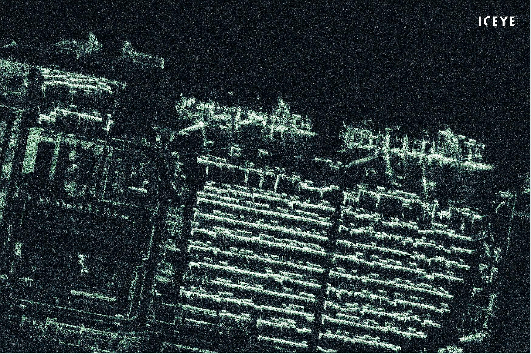
Each satellite of the ICEYE constellation carries an X-band Synthetic Aperture Radar (SAR), allowing the instruments to “see” through darkness, clouds and rain to observe Earth at all times. ICEYE uses the X-band frequency of 9.75 GHz at a wavelength of around 3 cm, and has a pulse rate frequency of 2-10 kHz.
ICEYE’s ability to persistently monitor locations is critical in order to detect high-frequency change and respond to real events that require a lot of decision-making; examples of this include natural disasters such as floods, vessel monitoring, and oil spill monitoring. ICEYE data is used in a variety of industries, including insurance, financial, energy, utilities, mining, civil, maritime and security.
Performance Specifications
ICEYE images in 4 distinct imaging modes:
- Spot imaging mode,
- Spot extended area (SLEA) imaging mode,
- Strip imaging mode,
- Scan imaging mode.
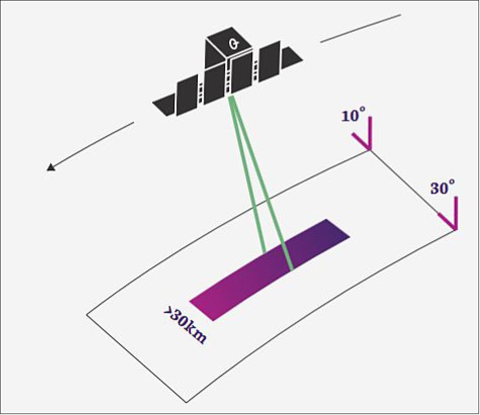
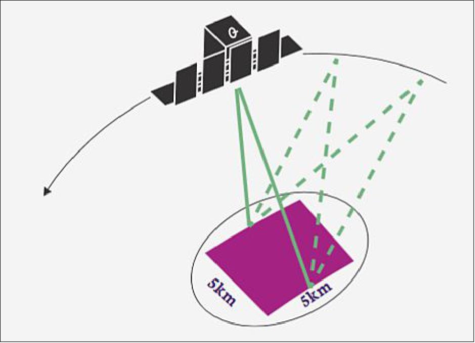
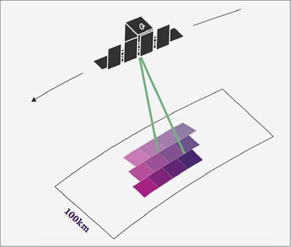
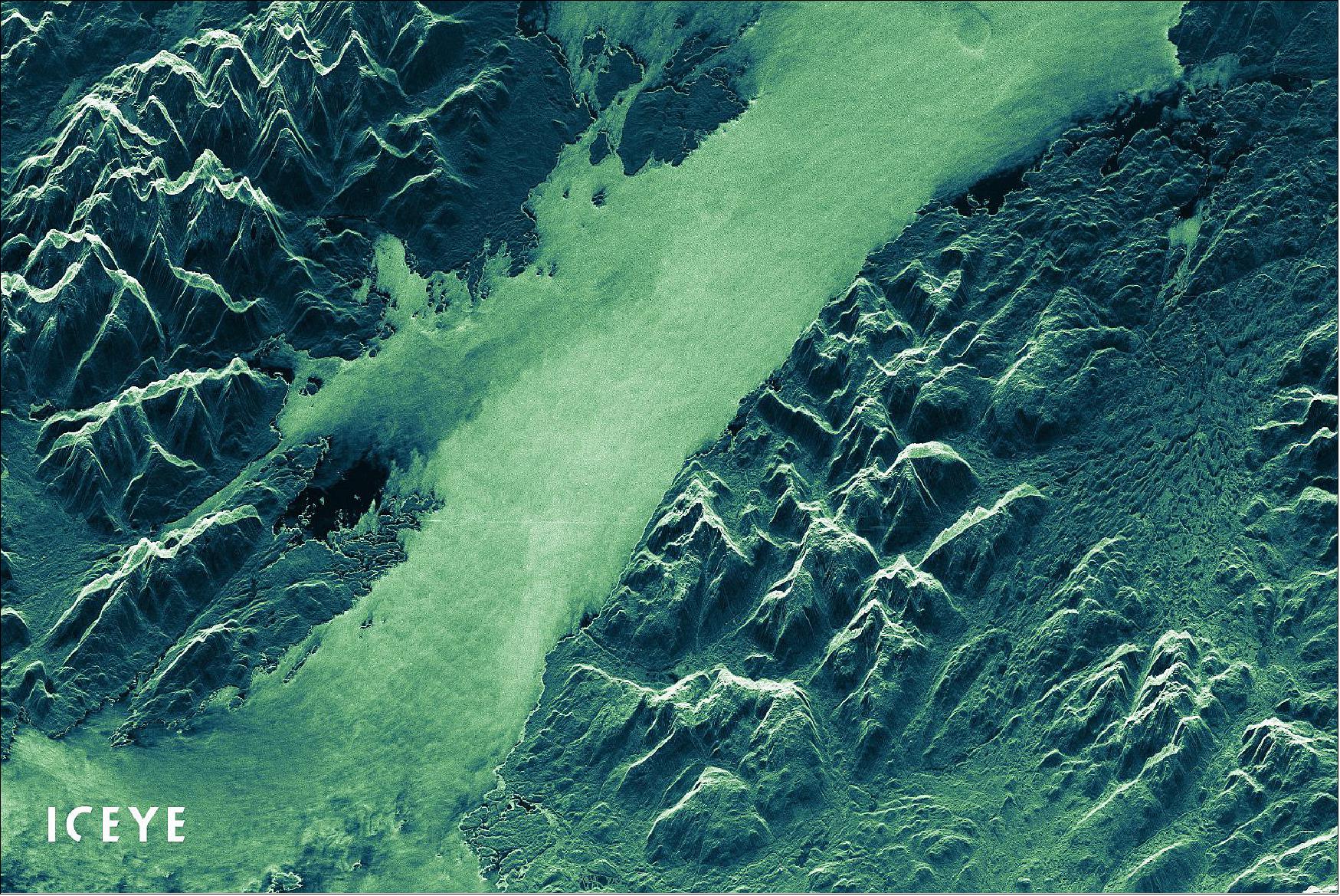
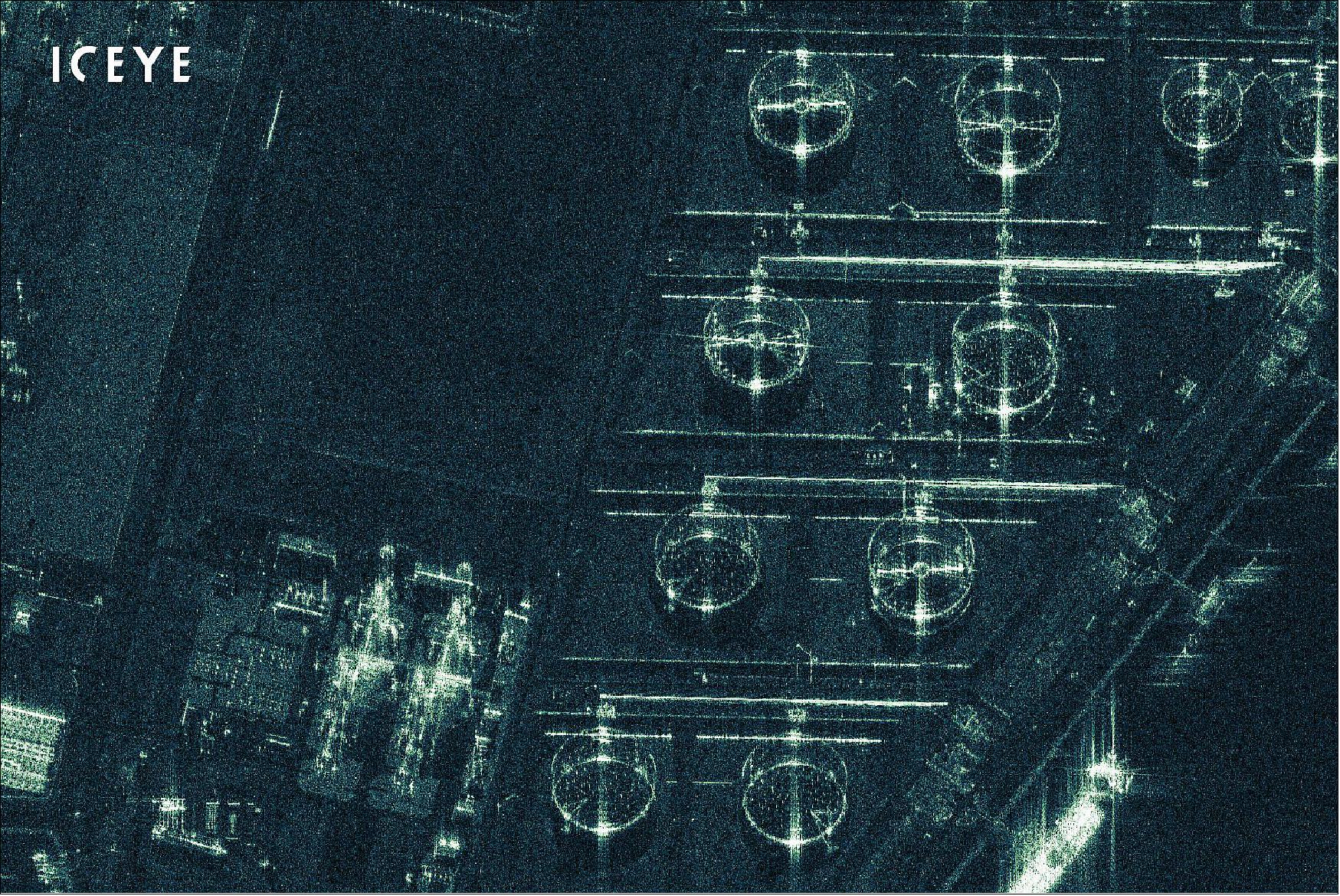
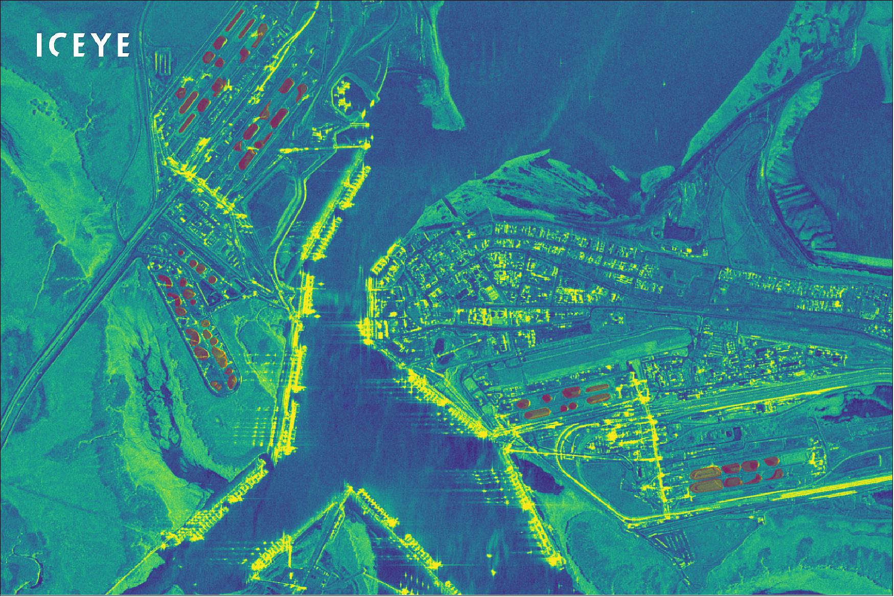
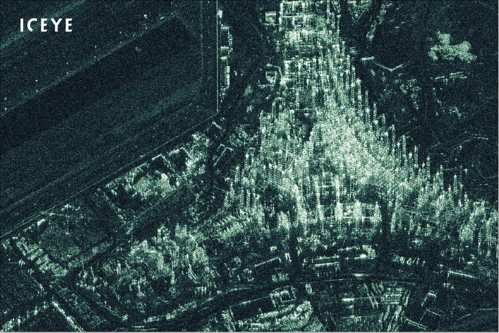
Spot mode offers the finest resolution available with a ground resolution of 1.0 m x 1.0m, and it is able to image a scene of size 5km x 5km at incidence angles of 20-35°. SLEA mode provides the largest very-high resolution SAR imagery with ground resolution of 1.0m x 1.0m and a scene size of 15 km x 15 km, or slant resolution of 0.5m x 1.0 m at incidence angles of 20-35°. Strip mode enables imaging of any area on Earth with spatial resolution of 3 m and scene size of 30 km x 50 km; it has a ground resolution of 3.0m x 3.0 m, and slant resolution of 0.5-2.5 m x 3.0 m at incidence angles of 15-30°. Scan imagining mode is a wide area imaging mode able to create a scene size of 100km x 100 km, with a ground resolution of 15m x 15 m at incidence angles of 21-29°.
Each satellite in the ICEYE constellation has a ground track repeat time of 17 day, with 21 satellites currently in orbit, this allows ICEYE to have daily coherent ground track repeat. When all 48 satellites are in orbit, this will enable twice daily revisit time over locations on Earth.
The ICEYE satellites are in sun-synchronous orbit at an inclination of 97.7° with an orbital frequency around 96 minutes.
Space and Hardware Components
Each ICEYE spacecraft has a mass of 85 kg, with X-band sensors utilising active phase array antennas that are electronically steerable, allowing the satellites the ability to look both left and right, with a range bandwidth between 40-300 MHz. The ICEYE satellites are able to downlink data to the ground for processing at 140 Mbit/s in the X-band range. ICEYE provides Level 1, 1a and 1b data products, that is, they can either be complex images which have both amplitude and phase values, or amplitude images which have amplitude-only pixels.
ICEYE Microsatellites Constellation
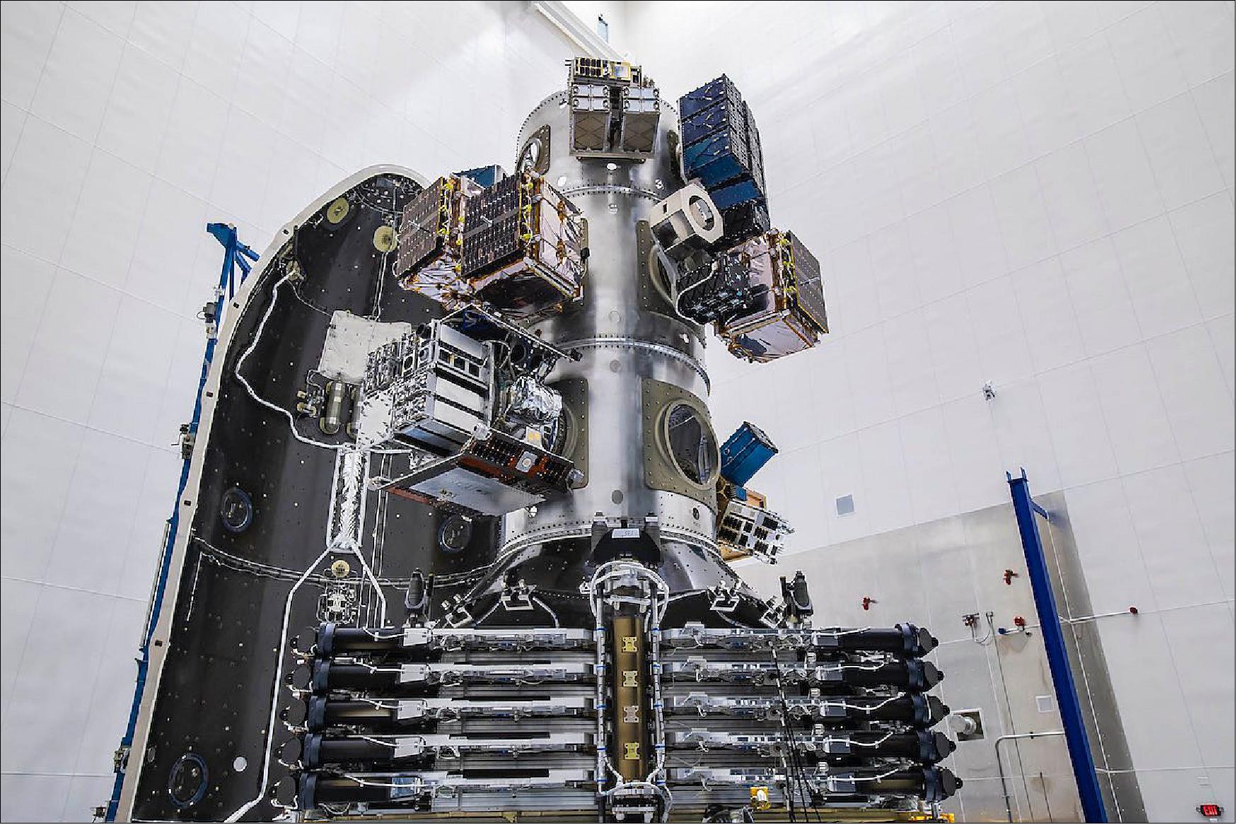
The commercial Earth Observation (EO) company ICEYE Ltd. of Espoo, Finland developed and built the ICEYE-X2 spacecraft with a SAR (Synthetic Aperture Radar) instrument suitable for a microsatellite. ICEYE-X2 features a range of technology improvements to increase the versatility and quality of the imaging data compared to ICEYE-X1. The improvements relate to items such as component choices, subsystem interfaces, software code, operations procedures, communication links, and optimization of power management. ICEYE-X2 possesses various imaging modes to provide imagery at high resolution and alternatively with a very wide swath to support different types of use cases. 1) 2)
Spacecraft and Sensor Complement
The ICEYE constellation will consist of approximately 18 operational X-band SAR (Synthetic Aperture Radar) small satellites. This new service puts an emphasis on superior reliability, a vastly higher rate of revisits to individual locations, and on objectivity. The service is based on a completely new satellite and sensor design, leveraging recent technological advancements and a New Space approach.
ICEYE SAR satellites, each with a mass of 85 kg, are side-looking X-band SAR sensors utilizing active phased array antenna (electronically steerable) technology. It is both right- and left-looking and capable of acquiring satellite imagery of Earth using stripmap, spotlight and ScanSAR imaging modes. ICEYE-X2, a typical representative instrument of the ICEYE constellation (Figure 1), is currently located on a sun-synchronous polar orbit with 17 days of ground track repeat cycle with 15 imaging orbits per day. Table 1 lists system and orbital parameters of presently available SAR instruments.
Parameter | ICEYE Constellation Specifications |
Carrier frequency | 9.65 GHz (X-band) |
Look side | Both left and right |
Antenna size | 3.2 m x 0.4 m |
PRF (Pulse Repetition Frequency) | 2-10 kHz |
Range bandwidth | 40-300 MHz |
RF peak power | 4 kW |
Polarization | VV |
Incidence angle range in Stripmap mode | 10-30º |
Incidence angle range in Spotlight mode | 20-35º |
Imaging Modes
ICEYE satellites collect SAR images in several standard imaging modes. ICEYE’s satellites are capable of imaging in Stripmap, Spotlight and ScanSAR modes, with Stripmap and Spotlight imagery operationally available for acquisition worldwide. Notably, all imaging beam modes are available in both right- and left-looking configuration.
Stripmap Imaging Mode
In Stripmap mode, the ground swath is illuminated with a continuous sequence of pulses while the antenna beam is fixed in elevation and azimuth. This results in an image strip with a continuous image quality in the flight direction.
Spotlight Imaging Mode
In Spotlight mode, mechanical antenna steering in the azimuth direction is used to increase the illumination time, resulting in an increased synthetic aperture and, therefore, better azimuth resolution compared to a continuous stripmap mode.
ScanSAR Imaging Mode
In ScanSAR mode, electronic antenna elevation steering is used to switch after bursts of pulses between swathes with different incidence angles. Due to the switching between the beams, only bursts of SAR echoes are received, resulting in a reduced azimuth bandwidth and hence, reduced azimuth resolution.
To obtain a more homogeneous radiometry and noise floor over the access range, each ICEYE ScanSAR beam will have an individual transmitted chirp range bandwidth which decreases with increasing incidence angle. The bandwidth is selected to achieve a targeted constant ground range resolution in the complex single look data. For detected products, multi-looking will be applied independently to each beam before merging into a combined swath.
ScanSAR is currently under development.
Parameter | Stripmap | Spotlight | ScanSAR (under development) |
Nominal swath width | 30 km | 5 km | - |
Nominal product length | 50 km | 5 km | - |
Look angles | 10-30º | 25-30º | - |
NESZ (Noise Equivalent Sigma Zero) | <-17 dB | <-17 dB | - |
AASR & RASR | <-17 dB | <-17 dB | - |
Number of elevation beams | 3 | - | - |
SLC, slant range resolution | 0.5 m (300 MHz), 1.5 m (100 MHz) | 0.6 (300 MHz) | - |
SLC, azimuth resolution | 2.5-3.0 m | 1 m | - |
SLC, range spacing | 0.4-1.7 m | 0.4 m | - |
SLC, azimuth spacing | 1.4-1.7 m | 0.35-0.7 m | - |
GRD, ground range resolution | 3.0 m | 1 m | - |
GRD, azimuth resolution | 2.5-3.0 m | 1 m | - |
Polarization | VV | VV | - |
Definitions: AASR (Azimuth Ambiguity to Signal Ratio); RASR (Range Ambiguity to Signal Ratio); SLC (Single Look Complex); GRD (Ground Range Detected).
Launches
ICEYE-X2
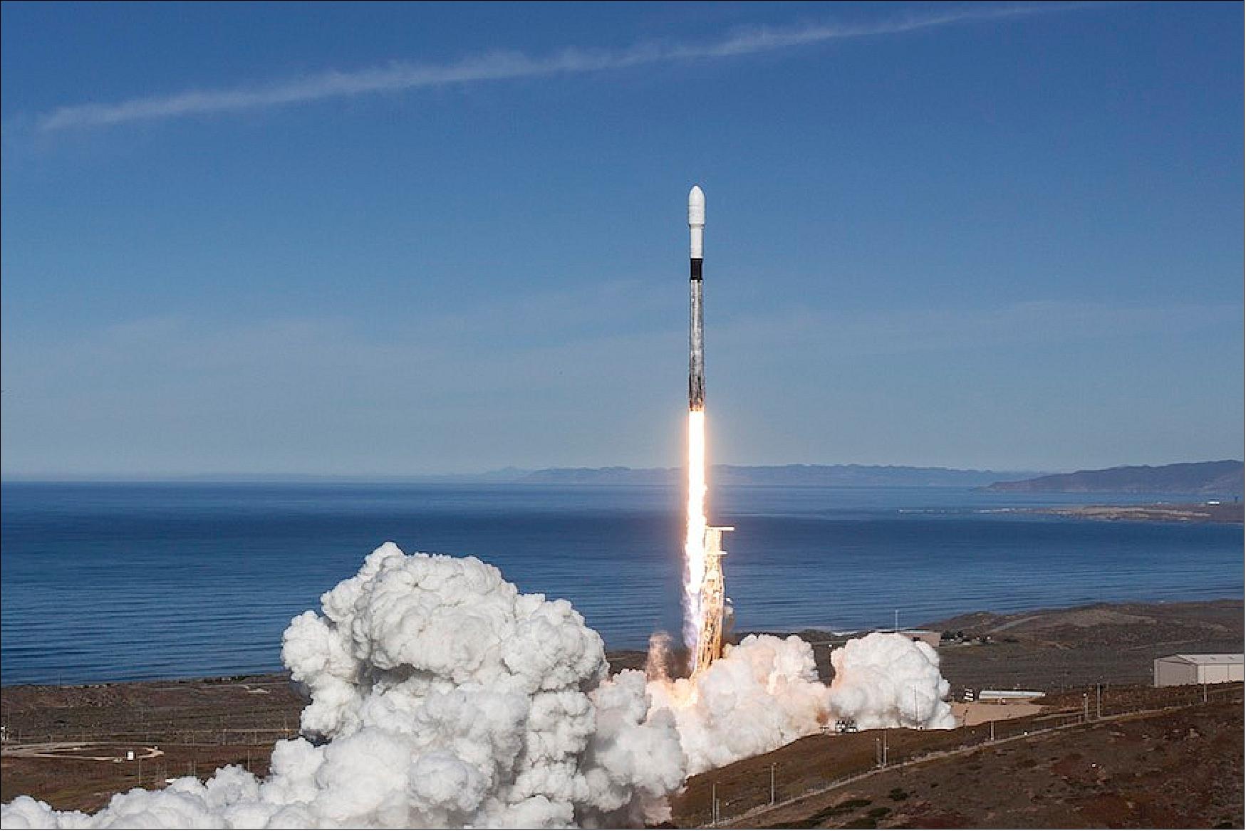
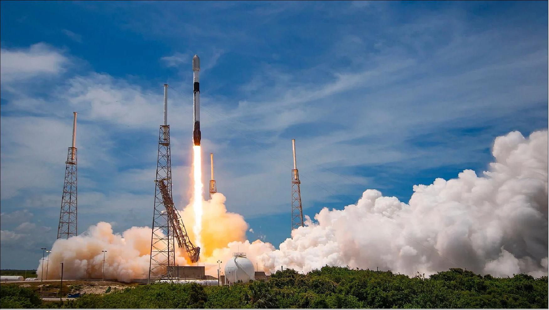
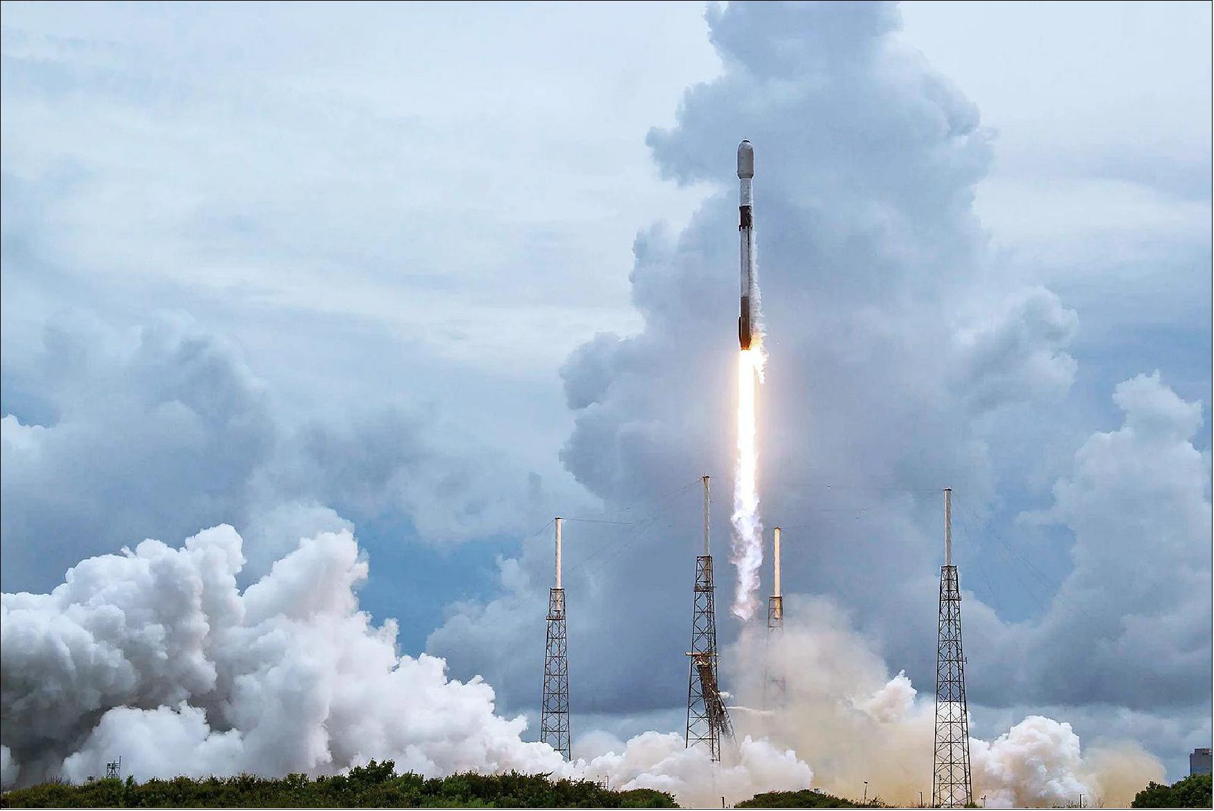
The two ICEYE-X2 (ICEYE POC2, COSPAR 2018-099AU)microsatellites wasere launched on the SSO-A rideshare mission of Spaceflight, on 3 December 2018 (18:34:05 GMT) on a SpaceX Falcon-9 Block 5 vehicle from VAFB (Vandenberg Air Force Base) in California. 3) 4) 5)
Orbit: Sun-synchronous circular orbit with an altitude of 570 km, inclination of 97.7º, LTDN (Local Time of Descending Node) of 10:30 hours, repeat cycle of 17 days.
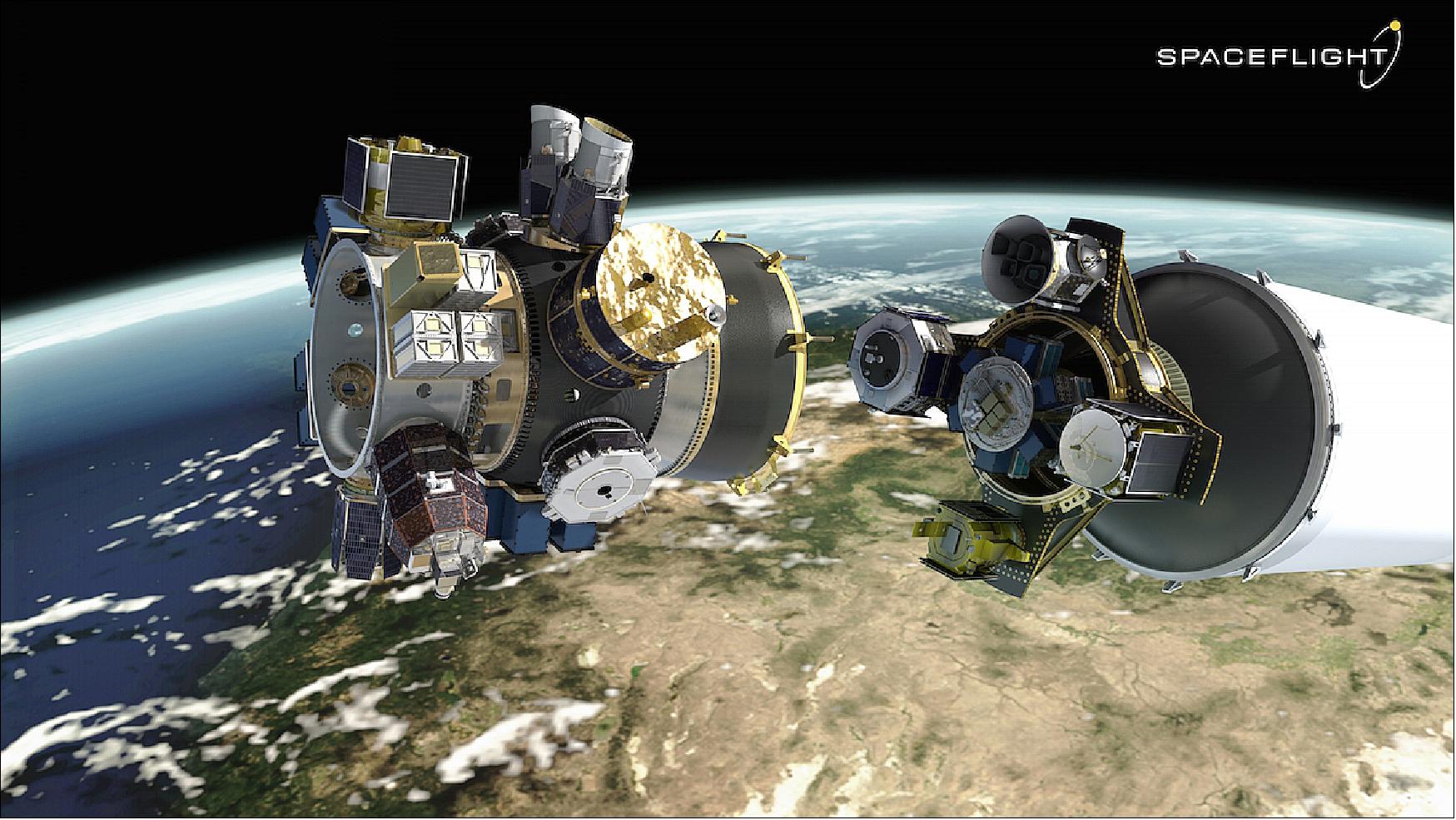
Payloads on the Spaceflight SSO-A Rideshare Mission
The layout of the list follows the alphabetical order of missions as presented on the Wikipedia page ”2018 in spaceflight” and with the help of Gunter Krebs's short descriptions.
This mission enabled 34 organizations from 17 different countries to place spacecraft on orbit. It’s also special because it was completely dedicated to smallsats. Spaceflight launched 15 microsatellite and 49 CubeSats from government and commercial entities including universities, startups, and even a middle school. The payloads vary from technology demonstrations and imaging satellites to educational research endeavors.
The secondary payloads on the Spaceflight SSO-A Rideshare mission also included:
• Astrocast-0.1, a 3U CubeSat technology demonstration mission of Astrocast, Switzerland, dedicated to the Internet of Things (IoT)
• BlackSky-2, a microsatellite (55 kg) of BlackSky Global (Seattle, WA) which will provide 1 m resolution imagery with improved geolocation accuracy.
• Capella-1, a microsatellite (37 kg) of Capella Space, San Francisco, CA featuring a X-band SAR (Synthetic Aperture) payload.
• ESEO (European Student Earth Orbiter) sponsored by ESA, a microsatellite of ~40 kg with 6 instruments aboard.
• Eu:CROPIS (Euglena and Combined Regenerative Organic-Food Production in Space), a minisatellite (230 kg) of DLR, Germany. The objective is to study food production in space in support of future long-duration manned space missions (life sciences). The main payloads are two greenhouses, each maintained as a pressurized closed loop system, simulating the environmental conditions of the Moon or of Mars
• Flock-3, three 3U CubeSats (5 kg each) of Planet Labs to provide Earth observation.
• HawkEye, a formation-flying cluster of three microsatellites (13.4 kg each) of HawkEye 360, Herndon, VA, USA. The goal is to demonstrate high-precision RFI (Radio Frequency Interference) geolocation technology monitoring.
• Hiber-1 and-2, these are 6U CubeSats, a pathfinder mission of Hiber Global, Noordwijk, The Netherlands, for Hiber Global's planned (IoT) communications CubeSat constellation.
• ITASAT-1 (Instituto Tecnológico de Aeronáutica Satellite), a Brazilian 6U Cubesat (~8kg) built by the Instituto Tecnológico de Aeronáutica (ITA). A former rescoped microsatellite mission.
• KazSTSAT (Kazakh Science and Technology Satellite), a microsatellite (<100 kg) of Ghalam LLP, Astana, Kazakhstan. Developed by SSTL on a SSTL-50 platform including an SSTL EarthMapper payload designed for global commercial wide-area imaging with a resolution of 17.5 m on a swath of 250 km.
• Landmapper-BC (Corvus BC 4), a 6U CubeSat (11 kg) of Astro Digital (formerly Aquila Space), Santa Clara, CA, USA. The satellite features a broad coverage multispectral (Red, Green, NIR) imaging system with a resolution of 22 m.
•MinXSS-2 (Miniature X-ray Solar Spectrometer-2), a 3U CubeSat(4 kg) of LASP (Laboratory for Atmospheric and Space Physics) at the University of Colorado at Boulder,CO, USA. The objective is to study the energy distribution of solar flare SXR (Soft X-ray) emissions and its impact on the Earth’s ITM (Ionosphere, Thermosphere, and Mesosphere) layers.MinXSS-2 is a copy of the MinXSS-1 but with some improvements. — MinXSS-1 was launched on 06 December 2015 onboard of Cygnus CRS-4 to the ISS, were it was deployed into orbit on 16 May 2016. It reentered Earth's atmosphere on 6 May 2017.
• SeaHawk-1, a 3U CubeSats of UNCW (University of North Carolina, Wilmington), NC. The goal is to measure the ocean color in project SOCON (Sustained Ocean Observation from Nanosatellites). SeaHawk is considered a prototype for a larger constellation. The SOCON project is a collaboration between Clyde Space Ltd (spacecraft bus), the University of North Carolina Wilmington, Cloudland Instruments, and NASA/GSFC (Goddard Space Flight Center).
• SkySat-14 and -15, Planet Labs of San Francisco has 13 SkySats in orbit. The commercial EO satellites were built by Terra Bella of Mountain View, CA, which Planet Labs acquired from Google last year. At the time of the purchase, there were 7 SkySats in orbit. On 31 October 2017, Planet launched an additional six on a Minotaur-C rocket. The 100 kg SkySats are capable of sub-meter resolution – making them the most powerful in the constellation. Customers can request to have these high-resolution satellites target their locations of interest.
• VESTA is a 3U CubeSat developed at SSTL in Guildford, UK. VESTA is a technology demonstration mission that will test a new two-way VHF Data Exchange System (VDES) payload for the exactEarth advanced maritime satellite constellation. Honeywell Aerospace is providing the payload. VESTA is a flagship project of the National Space Technology Program, funded by the UK Space Agency and managed by the Center for EO Instrumentation and Space Technology (CEOI-ST).
Spaceflight has contracted with 64 spacecraft from 34 different organizations for the mission to a Sun-Synchronous Low Earth Orbit. It includes 15 microsatellites and 49 CubeSats from both commercial and government entities, of which more than 25 are from international organizations from 17 countries, including United States, Australia, Italy, Netherlands, Finland, South Korea, Spain, Switzerland, UK, Germany, Jordan, Kazakhstan, Thailand, Poland, Canada, Brazil, and India. 6)
ICEYE-X3
The ICEYE-X3 (Harbinger) mission was launched on 5 May 2019 at 05:41 UTC, as a demonstration payload of York Space System's (Denver, CO) S-class satellite bus. Harbinger was launched on an Electron KS mission of Rocket Lab on the STP-27RD mission from New Zealand's Māhia Peninsula, sponsored by the U.S Army. The payloads on this mission included the ICEYE-X3, BridgeSat's optical communications payload and Enpulsion of Austria's Field Emission Electric Propulsion system.
Orbit: Sun-synchronous orbit at an altitude of 500 km, and an inclination of 40.0º.
ICEYE-X4 and ICEYE-X5
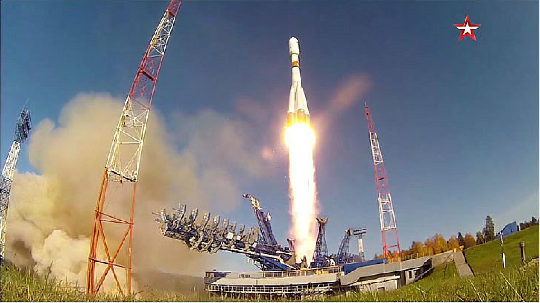
The ICEYE-X4 and ICEYE-X5 satellites of ICEYE were launched as secondary payloads on a Soyuz-2-1b Fregat M rocket on 5 July 2019 (05:41 UTC) from the Vostochny Cosmodrome, Russia. The primary mission on this flight was the Meteor-M 2-2 satellite (2750 kg), a new generation meteorological mission of Russia, developed by VNIIEM and operated by Roskosmos. 7) 8)
Orbit: Sun-synchronous orbit with an altitude of 580 km and inclination of 98º.
The secondary payloads on the Soyuz-2-1b Fregat M rocket also included:
• Lemur-2 x 8, of Spire Global Inc., USA (8 3 U CubeSats)
• SONATE, an experimental 3U CubeSat of the University of Würzburg, Germany
• DoT-1, a (Demonstration of Technology) microsatellite (18 kg) of SSTL, UK
ICEYE-X6 and ICEYE-X7
The ICEYE-X6 and ICEYE-X7 microsatellites of ICEYE were launched as a secondary payloads on 28 September 2020 (11:20 UTC) on a Soyuz-2.1b/Fregat rideshare mission of Roskosmos from the Plesetsk Cosmodrome Site43/4 in Russia. The primary payload on this flight were three Gonets-M (No 27-29) civilian communication microsatellites with a total mass of ~840 kg. 9)
Orbit: Sun-synchronous orbit with an altitude of 580 km with an inclination approximately 97.7º.
Orbit (secondary payloads): Sun-synchronous orbit, altitude of ~575-600 km with an inclination close to 97º.
A total of 19 small satellites were part of this rideshare mission, 15 CubeSats of which were managed and integrated by the services of Exolaunch of Berlin, Germany. Exolaunch uses ExoPods for the deployment of the CubeSats. 10) Exolaunch is a rideshare launch and deployment solution provider for small satellites. Its flight heritage includes the successful deployment of nearly 100 small satellites into orbit, in cooperation with launch vehicle providers worldwide. 11) Additionally, four small Russian satellites were also booked for the same mission. 12)
The secondary payloads on the Soyuz-2.1b/Fregat rideshare mission of Roskosmos, also included:
• Lemur-2, Four 3U CubeSats of Spire Global Inc., San Francisco, CA (provision of Earth observation). Two of the Spire nanosatellites have an onboard supercomputer and intelligent machine-learning algorithms that can provide hyper-accurate predictions of the locations of boats, track their whereabouts and calculate their arrival times at ports, allowing port businesses and authorities to manage busy docks safely. Two further Spire satellites launched alongside them, both of which will be used to forge inter-satellite links. These connections allow satellites to act as relays, sending data to one another and down to ground stations, which cuts the time between data collection and its delivery. - Made by Spire Global UK, the nanosatellites, which are some of the smartest satellites ever built in the UK, are backed by over £10 million of investment from the UK Space Agency. 13)
ICEYE-X8, - X9 and -X10
On 24 January 2021 at at 10:00 EST (15:00 UTC), three new satellites (ICEYE-X8, ICEYE-X9 and ICEYE-X10) were launched from Cape Canaveral SLC40 as part of record setting Falcon 9 Flight 106 (i.e. Transporter-1 mission).
One of these, the ICEYE-X10, is a US-built version of the ICEYE satellites developed by R2 Space for the US government and has been renamed XR-1. 69)
Orbit: Sun-synchronous Orbit with an altitude of 500 km and an inclination of 97.4º. 71)
ICEYE-X11, -X12, -X13 and -X15
On 30 June 2021 at 3:31 PM ET, SpaceX and ICEYE launched from Launch Pad 40 on Cape Canaveral Air Force, an additional four satellites onboard the Falcon 9 Block 5 rockets of the Transporter-2 mission.
Orbit: Sun-synchronous Orbit with an altitude of approximately 500 km and an inclination of 97.4º.
ICEYE-X14 and ICEYE-X16
On 13 January 2022 at 15:25 UTC, two additional satellites were launched onboard Falcon 9 launch of Transporter-3, from Space Launch Complex 40 (SLC-40) at Cape Canaveral Space Force.
Orbit: Sun-synchronous orbit with an altitude of approximately 500 km and an inclination of 97.4º.
ICEYE-X17, -X18, -X19, -X20 and -X24
Another five satellites were launched on 25 May 2022 at 18:35 UTC, as part of the Transporter-5 mission.
Orbit: Sun-synchronous Orbit with an altitude of approximately 500 km and an inclination of 97.5º.
ICEYE-X21, -X22 and -X27
Three further ICEYE satellites were launched on 3 January 2023 at 9:56 AM EST (14:56 UTC), as part of the Transporter-6 mission.
Unfortunately, out of those last three satellites only two are currently in orbit while ICEYE X22 failed to separate from the rocket upper stage representing the first loss of a satellite for ICEYE.
Orbit: Sun-synchronous Orbit with an altitude of approximately 530 km and an inclination of 97.5º.
ICEYE-X23, -X25, -X26 and X30I
On 12 June 2023, ICEYE launched four more satellites on SpaceX’s Transporter-8 smallsat rideshare mission via Exolaunch was conducted from Vandenberg Space Force Base in California, USA. 70)
Orbit: Sun-synchronous Orbit with an altitude of approximately 532 km and an inclination of 97.5º.
ICEYE-X31, X32, X34 and X35
On 11 November 2023, ICEYE launched four more satellites on SpaceX’s Transporter-9 rideshare mission, from launch complex SLC-4E, at Vandenberg Space Force Base (VSFB). The rocket lifted off at 10:49 AM PST (18:49 UTC). 77)
Orbit: Sun-synchronous circular orbit with an altitude of 560 to 580 km and an inclination of 97.7º. 76)
ICEYE-X36, X37, X38
SpaceX launched ICEYE-X36, X37, X38 on the Transporter-10 rideshare mission from Space Launch Complex 4E at Vandenberg Space Force Base (VSFB). Liftoff occurred at 2:05 PM PST (22:05 UTC).
Deployment of payloads from the second stage to two Sun-synchronous orbits (SSO) began almost an hour after launch and lasted until two hours and 33 minutes after launch, including moving to the second orbit.
Orbit: Sun-synchronous orbit with an altitude of 520 to 600 km and an inclination of 97.8º. 79)
Mission Status
• March 4, 2024: ICEYE successfully launched three additional X-band SAR satellites named ICEYE-X36, X37 and X38, including a 1200 MHz radar bandwidth in-orbit technology demonstrator.
The satellites were integrated via launch integrator Exolaunch and successfully lifted off aboard SpaceX’s Transporter-10 rideshare from Vandenberg Space Force Base in California, USA. Each spacecraft has established communication, and early routine operations are underway.
Two of the three SAR satellites launched on the mission are manufactured by ICEYE US, while one is an in-orbit technology demonstrator manufactured by ICEYE Finland. The in-orbit demonstrator model features an upgrade to ICEYE’s unique X-band antenna, increasing radar bandwidth to 1200 MHz. This enables higher-resolution imagery, up to 25 cm, and will be initially assigned to engineering tests before being made available to ICEYE customers. 78)
• November 11, 2023: ICEYE has successfully expanded its constellation with four new synthetic aperture radar (SAR) satellites, ICEYE-X31, X32, X34 and X35. The launch on SpaceX’s Transporter-9 smallsat rideshare mission via Exolaunch was conducted from Vandenberg Space Force Base in California, USA. Each spacecraft has successfully established communications and is undergoing routine early operations.
ICEYE has now deployed 31 satellites since 2018, underscoring the company’s position as a world leader in SAR satellite technology. As the owner and operator of the largest SAR satellite fleet, ICEYE can provide customers with faster access to data in emergencies and the highest revisit rates for high-frequency phenomena.
The launch of the four third-generation satellites also builds on earlier advancements in imaging capabilities, including Spot Fine mode, which delivers 50 cm native ground resolution, and Dwell mode, which uses advanced collection techniques to rapidly determine changes happening on the ground in near real-time. 75)
• August 9, 2023: ICEYE US Inc. has received its first Task Order under a Blanket Purchase Agreement (BPA) with NASA. This Task Order allows NASA to acquire ICEYE's synthetic-aperture radar (SAR) data for evaluation in advancing NASA's Earth Science research objectives. The BPA is funded by NASA's Earth Science Division of the Science Mission Directorate. This agreement marks a significant milestone for commercial SAR data in the United States, providing NASA with access to ICEYE's archive of tens of thousands of images and supporting advanced time series analysis of Earth's surface. 74)
• June 12, 2023: ICEYE, known for its radar imaging satellites and expertise in natural catastrophe solutions, has successfully expanded its constellation with four new synthetic aperture radar (“SAR”) satellites. ICEYE-X23, -X25, -X26 and X30I, were launched on SpaceX’s Transporter-8 smallsat rideshare mission via Exolaunch was conducted from Vandenberg Space Force Base in California, USA. 73)
• January 3, 2023: ICEYE-X21, X22 and X27 were launched at 14:56 UTC from Space Launch Complex 40 (SLC-40) at Cape Canaveral Space Force Station (CCSFS).
• September 14, 2022: ICEYE and SATLANTIS have announced preliminary plans to develop a Tandem for Earth Observation (Tandem4EO) constellation consisting of two radar and two very high-resolution optical satellites. These satellites will be capable of under 1-meter resolution imaging and will serve applications related to natural catastrophes, security, environmental monitoring, infrastructure development, SAR Interferometry (InSAR) based change detection, and more. The combination of SAR and optical imaging with video capability in a single constellation is expected to provide versatile and reliable insights for stakeholders in Spain and Europe. 72)
• July 14, 2022: ICEYE, a provider of natural catastrophe data, is collaborating with the Ghana Ministry of Finance, the United Nations Development Programme (UNDP), and the Insurance Development Forum (IDF) in a groundbreaking risk transfer project. Spearheaded by Allianz and Swiss Re, with support from UNDP, the initiative aims to bolster the Ghanaian government's ability to respond to urban flooding and enhance socioeconomic resilience in the Greater Accra Region. Central to the project is a parametric flood insurance solution, utilizing ICEYE's high-resolution hazard data to verify flood extent and depth. This comprehensive approach minimizes basis risk, ensuring timely and expected payouts, while also informing response and recovery decisions. UNDP Ghana sees this project as a means to build resilience, improve access to insurance, and advance the nation's development agenda through innovative risk management. The initiative represents a unique regional effort to break barriers, reduce basis risk, and enhance disaster recovery outcomes, backed by ICEYE's advanced satellite data capabilities. 20)
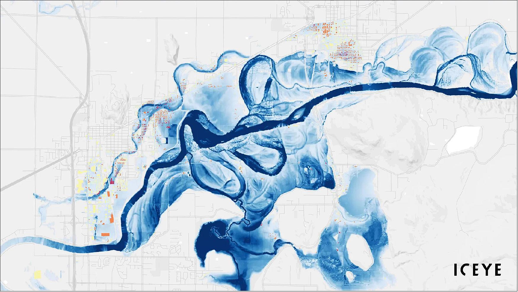
• June 29, 2022: ICEYE has launched ICEYE Insights, a powerful geospatial platform for global insurance companies to integrate their property insurance data with ICEYE's flood observation data and analysis. Using the EigenPrism® catastrophe risk management tool, the platform updates in near-real-time with ICEYE's Flood Insights data after a flood event, providing high-resolution flood extent reporting and depth measurements for individual buildings. Insurers can upload their property portfolio details via an API and gain instant insights into flood impacts on their customers. ICEYE Insights facilitates rapid communication with customers, resource allocation, claims triage, early settlements, damage cost estimates, and reserve optimization. This platform offers a convenient and cost-effective way for insurers to utilize ICEYE's flood data to enhance their underwriting and response to flooding events, leveraging ICEYE's extensive synthetic-aperture radar constellation for persistent monitoring capabilities in various sectors. 21)

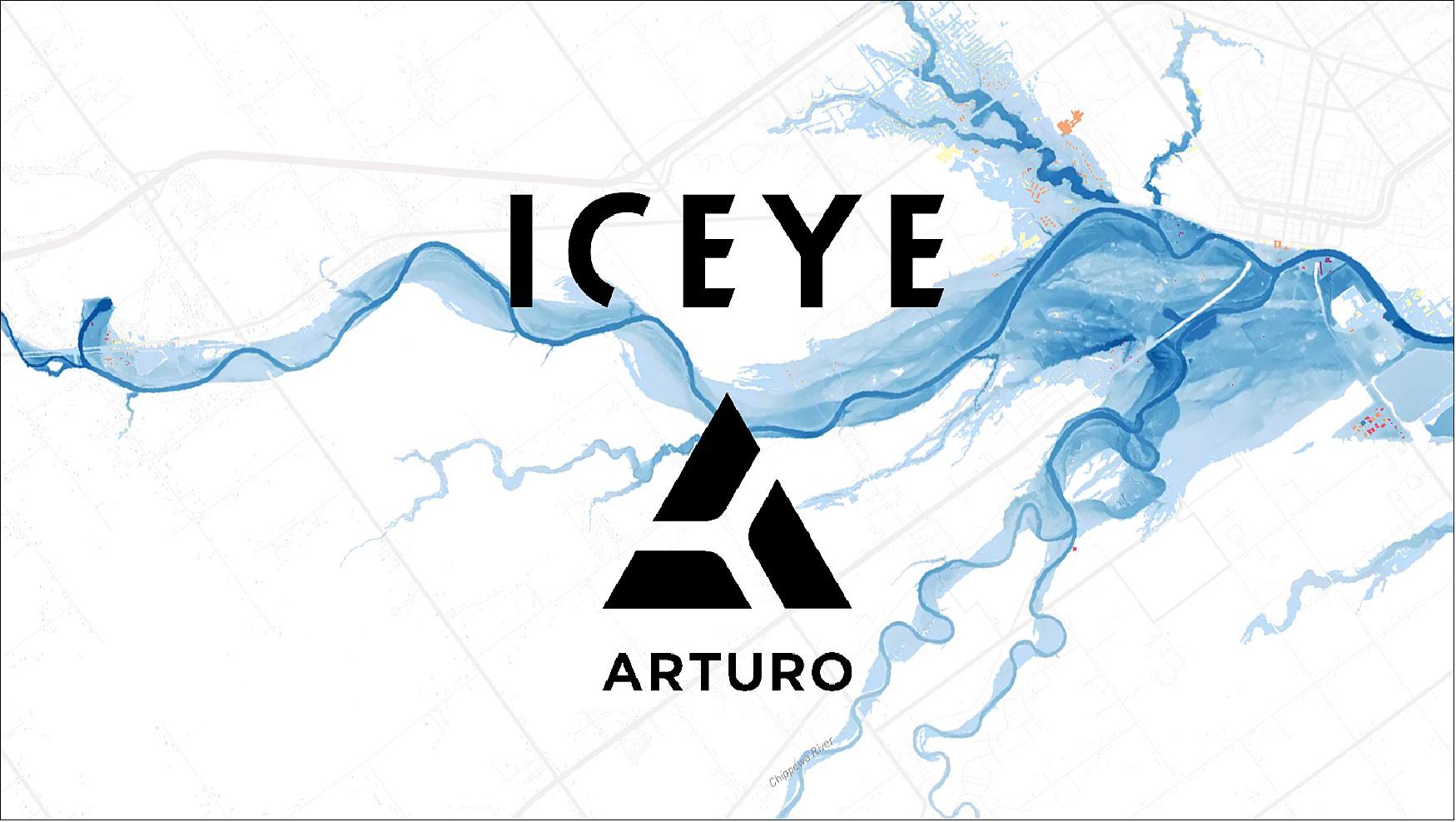
• May 25, 2022: Arturo, the proptech firm specializing in property analytics, and ICEYE, a SAR data provider with expertise in natural catastrophe solutions, have announced a transformative partnership that redefines insurance responses to flood events. ICEYE's near real-time flood imagery, offering detailed information on flood depth, extent, and duration, will be integrated with Arturo's property characteristics data, enabling insurers to swiftly estimate and assess flood damage immediately following such events. ICEYE utilizes the world's largest SAR satellite constellation, combining spaceborne sensor data with ground-based information to provide precise flood information globally. When combined with Arturo's AI-driven property analytics, this collaboration empowers insurers to assess property damage rapidly, evaluate ongoing risk, estimate claims payouts across portfolios, and promptly assist policyholders. This partnership, successfully tested during a March 2022 flood event in Australia, demonstrates the potential for insurers to enhance customer loyalty by predicting flood damage and expediting claims processing. By offering near real-time hazard data, ICEYE and Arturo aim to improve decision-making and enable faster responses to floods throughout the insurance sector. Initially focused on flood depth insights for the United States, Canada, Japan, and Australia, the collaboration invites select insurers to explore this innovative solution at the Insurtech Insights Americas event in New York City on May 25 and 26. 22)
• 25 May 2022: On the SpaceX Falcon 9 Transporter-5 mission from Cape Canaveral, Florida, ICEYE launched five new SAR (Synthetic Aperture Radar) satellites successfully at 18:35 UTC (2:35 p.m. EDT). These satellites, which have established communication, expand ICEYE's growing constellation, making it a total of 21 satellites deployed since 2018, encompassing both commercial and dedicated customer missions. Additionally, the launch marked the introduction of two new ICEYE US satellites, operated from the company's Mission Operations Center in Irvine, California, and licensed by the National Oceanic and Atmospheric Administration (NOAA). This expansion enables ICEYE to better serve U.S. government needs by integrating commercial remote sensing technologies into their collection strategies. Notably, two of the launched satellites are designated for use by the Brazilian Air Force, offering critical advantages in earth imaging for environmental and national security purposes, particularly in cloudy conditions. ICEYE plans further satellite additions to its constellation later this year, including more produced by ICEYE US. 19)
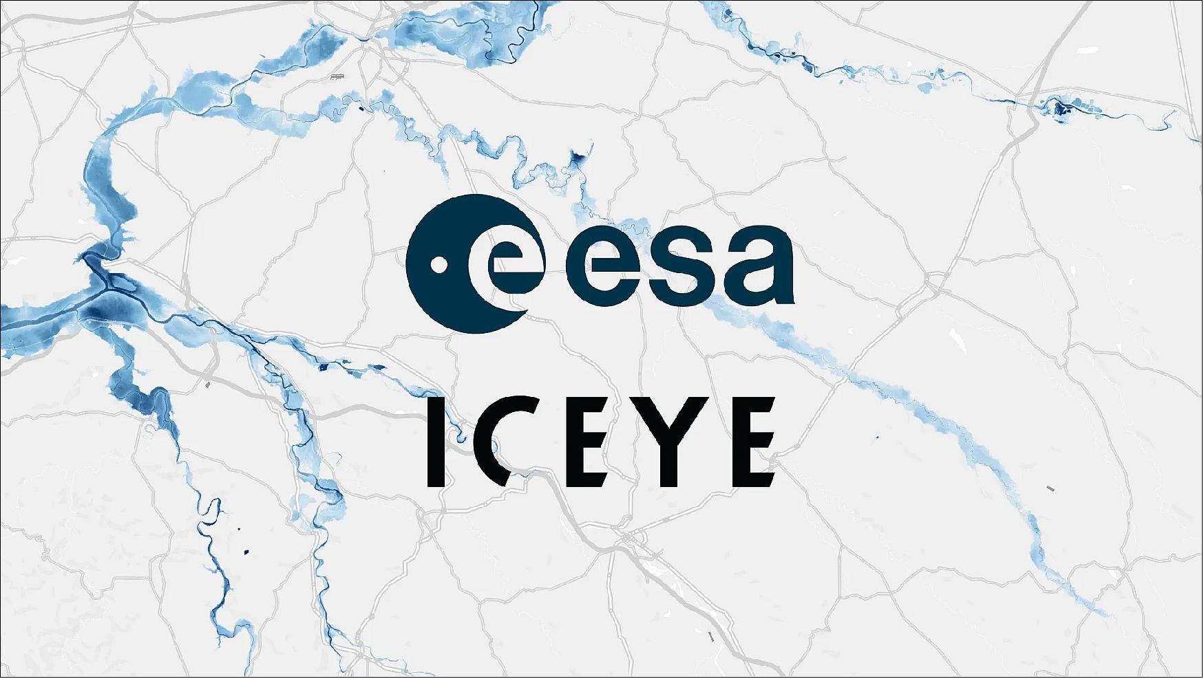
• May 23, 2022: ICEYE has initiated a pilot project in collaboration with the European Space Agency (ESA) to support the Copernicus Emergency Management Services (CEMS) team in flood monitoring. ICEYE, with the world's largest synthetic-aperture radar satellite constellation, will provide critical flood impact information, including flood extent and depth at the structure level, to ESA and CEMS throughout 2022. This pilot aims to help CEMS better understand the impacts of flooding in developed areas in near real-time. It is ICEYE's third and most extensive pilot with ESA, following previous projects involving volcanic eruption monitoring and sea-ice mapping. This partnership further solidifies ICEYE's role in the evolution of CEMS Rapid Mapping & Risk/Recovery components and aligns with ICEYE's mission to support data-driven decision-making in areas like insurance and natural catastrophe response and recovery. ICEYE became a Copernicus Contributing mission partner in October 2021, providing SAR imagery to enhance public safety, border control, security, and maritime domain awareness. The Copernicus Contributing Mission Activity is managed by ESA on behalf of the European Commission, with various entities benefiting from the data, including public authorities in Europe. 23)
• May 9, 2022: ICEYE and Neptune Flood have entered a strategic collaboration to advance flood insurance solutions. ICEYE's CEO and Co-Founder, Rafal Modrzewski, emphasized their commitment to this partnership, noting that their collaboration with Neptune, the largest and most technologically advanced flood insurance company in the United States, will enable the provision of near real-time insights into the extent and impact of flood events at the individual building level. This hazard insight is expected to enhance loss sizing, claims response capabilities, and accelerate innovation in flood insurance. 24)
• April 20, 2022: ICEYE has joined forces with EigenRisk, a leading independent insurance technology platform provider, to integrate ICEYE's unique flood insights for large-scale flood events into EigenPrism, a cloud-based catastrophe risk management platform. EigenPrism offers a comprehensive platform for catastrophe data, analytics, modeling, and reporting across major perils, enabling enhanced planning, monitoring, and response capabilities for global catastrophes. ICEYE's extensive SAR satellite constellation, combined with auxiliary information sources, provides near real-time flood observation data, including accurate flood extent footprints and detailed flood depth measurements at the individual building level. This collaboration is crucial in addressing the increasing threats posed by global climate change and flood exposures, benefiting businesses, communities, government entities, insurers, and reinsurance companies by facilitating timely event response and loss assessments. 25)
• March 15, 2022: ICEYE, a data provider of SAR with expertise in natural catastrophe solutions, has formed a strategic collaboration with Fermat Capital Management, one of the largest investment managers in the insurance-linked securities (ILS) sector. ICEYE will provide Fermat with near real-time flood hazard data, including high-resolution flood data for large-scale events, encompassing flood extent and depth at the building level. This collaboration aims to explore potential new use cases, such as wildfire-related events, leveraging ICEYE's extensive SAR satellite constellation and auxiliary data sources. By offering granular insights into natural catastrophes, this partnership enhances the private re/insurance and ILS market's ability to respond to climate shocks and improve resilience. ICEYE's advanced capabilities in persistent monitoring and rapid data delivery play a crucial role in evolving the capital markets' approach to high-gradient perils like floods, benefiting both investors and communities by facilitating timely responses and solutions in the face of natural disasters. 26)
• March 8, 2022: ICEYE has achieved recognition as one of Fast Company's World's Most Innovative Companies for 2022, securing the second spot in the Most Innovative Company Europe, Middle East, and Africa category. Fast Company's annual list highlights businesses that are making significant impacts in their industries and culture, effectively adapting to the ever-changing contemporary world. These companies are at the forefront of innovation, shaping the future with remarkable accomplishments in the 21st century. With a total of 528 organizations recognized across 52 categories, ICEYE's dedication to delivering outstanding results with unmatched timelines and service quality has earned it a well-deserved place on this prestigious list. Rafal Modrzewski, CEO, and Co-founder of ICEYE expressed his honor and gratitude for this recognition. 27)
• February 8, 2022: ICEYE has revealed that Tokio Marine Holdings (Tokio Marine) has made a strategic investment in the company, as part of ICEYE's Series D funding round led by Seraphim Space, raising a total of $136 million. This partnership aims to develop innovative insurance products and services that leverage satellite data to address the growing impact of climate change and the increasing frequency of natural catastrophes. ICEYE and Tokio Marine will collaborate on several initiatives, including enhancing insurance claims services for wind-related damage using satellite imagery, expediting insurance claims payments, and improving disaster detection capabilities through satellite data. This alliance builds on their previous work on an insurance claims processing solution for floods and demonstrates their shared commitment to proactive risk management and support for customers and society in times of crisis. Rafal Modrzewski, CEO and Co-founder of ICEYE, highlighted the potential of satellite data, analytical capabilities, artificial intelligence, and machine learning to enhance responsiveness, claims management, and disaster detection in the insurance industry. Masashi Namatame, Group Chief Digital Officer at Tokio Marine Holdings, expressed confidence in the collaboration's ability to address natural catastrophe risks effectively. 28)
• February 3, 2022: ICEYE has successfully concluded a Series D funding round, raising a total of $136 million and bringing the company's total financing to $304 million since 2015. This round was led by Seraphim Space and saw participation from strategic investors like BAE Systems and Kajima Ventures, as well as other contributors such as Molten Ventures, OTB Ventures, True Ventures, C16 Ventures, and more. ICEYE, the world's largest operator of SAR imaging satellites, plans to utilize this capital to enhance its Natural Catastrophe solutions, advance its satellite constellation and technology, and expand its global presence, particularly in analytics services involving artificial intelligence and machine learning. The funding will also enable ICEYE to reduce satellite access time and increase visiting frequencies. The company's SAR satellite constellation facilitates applications such as insurance loss adjustment, disaster response and recovery, national security, humanitarian relief, and climate change monitoring. CEO and Co-founder Rafal Modrzewski expressed pride in the company's reputation for delivering timely and high-quality service, emphasizing their commitment to further improving it. Susan Repo, Chief Financial Officer at ICEYE, noted that this funding will support their mission to meet customers' needs effectively. The company's rapid in-house satellite manufacturing was demonstrated with the recent launch of two SAR satellites from Cape Canaveral, Florida. Additionally, ICEYE secured investment through the European Investment Fund's InnovFin For Equity program, in conjunction with OTB Ventures. 29)
• January 20, 2022: ICEYE US, a subsidiary of ICEYE, has secured a contract from the National Reconnaissance Office (NRO) to participate in the evaluation of commercial remote sensing companies operating Synthetic Aperture Radar (SAR) satellites. ICEYE US will focus on modeling and simulation to support the NRO's detailed assessment of imaging modes, image quality, geolocation accuracy, and coverage, among other technical parameters. This contract is a significant milestone in the NRO's strategy to leverage next-generation commercial radar providers to deliver innovative, resilient, and responsive satellite imagery for intelligence, defense, and humanitarian purposes. ICEYE US, which operates U.S.-licensed SAR spacecraft, is dedicated to advancing commercial remote sensing capabilities for the U.S. Government and enhancing the NRO's access to flight-proven satellites that capture high-resolution radar imagery worldwide. Eric Jensen, President of ICEYE US, emphasized the partnership's objective to provide global situational awareness and meet future U.S. Government GEOINT requirements, ensuring critical decision-making is supported with relevant, high-quality data. ICEYE's radar imaging satellites offer a unique capability to observe Earth's surface in daylight, at night, and through cloud cover, providing persistent coverage of rapidly evolving events in all weather conditions. 30)
• January 13, 2022: ICEYE has successfully launched its fifteenth and sixteenth SAR satellites as part of SpaceX's Transporter-3 mission from Cape Canaveral, Florida. This launch also included ICEYE's first satellite built, licensed, and operated by ICEYE US, signifying a significant milestone for the company. Communication with both spacecraft has been successfully established. With these additions, ICEYE has now deployed a total of 16 satellites since 2018, encompassing commercial and dedicated customer missions. ICEYE's constellation enables reliable and frequent Earth imagery capture, facilitating the rapid detection of surface changes regardless of weather conditions or time of day. This capability finds applications in insurance, natural catastrophe response, national security, defense, humanitarian relief, and climate change monitoring. Rafal Modrzewski, CEO and Co-founder of ICEYE, emphasized that this expansion enhances the company's ability to provide solutions and advanced analytics for customers, especially in the context of machine learning and artificial intelligence applied to SAR technologies. Jerry Welsh, CEO of ICEYE US, highlighted the significance of launching their first U.S.-built and licensed satellite, marking progress in expanding U.S. operations and customer base.16) 17) 18)
• December 15, 2021: MDA Ldt. and ICEYE have entered into an agreement for ICEYE to supply an X-band Synthetic Aperture Radar (SAR) spacecraft for MDA's CHORUS, a next-generation commercial Earth observation mission. CHORUS aims to create a collaborative multi-sensor constellation, including C-band and X-band SAR satellites in a unique mid-inclination orbit, allowing day or night imaging in all weather conditions. This approach will provide extensive radar imaging capacity, including higher imaging performance, faster tasking, and Near Real-Time (NRT) data exploitation aided by machine learning and artificial intelligence. CHORUS's features include dedicated vessel detection imaging modes, precise all-weather satellite monitoring of icebergs, and tipping and cueing operations between wide area surveillance and high-resolution point target monitoring, among others. Additionally, MDA will be able to sell ICEYE's X-band data to select RADARSAT-2 customers, enabling advanced information data integration and analytics. Rafal Modrzewski, CEO and Co-founder of ICEYE, expressed enthusiasm for the collaboration, emphasizing ICEYE's role in providing best-in-class SAR capability to MDA's CHORUS constellation. 31)
• December 2, 2021: ICEYE has announced the opening of a new office in Luxembourg, which will also house the company's Machine Learning Center of Excellence. This center will focus on advancing machine learning and artificial intelligence for synthetic-aperture radar (SAR) and Earth observation technologies. ICEYE's decision to establish an office in Luxembourg was facilitated by the Luxembourg Future Fund (LFF), which aims to attract venture capital fund managers and innovative businesses to the country. The LFF is backed by the European Investment Fund and the Société Nationale de Crédit et d’Investissement (SNCI) and supports the diversification and sustainable development of Luxembourg's economy. The new office, located in Luxembourg City's historical neighborhood of Ville Haute, will help ICEYE attract top talent and strengthen its position in the growing space and satellite sector. 32)

• November 18, 2021: ICEYE has entered into a cooperative research and development agreement (CRADA) with the U.S. Army's Space and Missile Defense Technical Center (SMDTC) to advance Earth observation technology for U.S. Army missions. This collaborative effort will focus on low-cost, on-orbit Synthetic Aperture Radar (SAR) concepts, including imagery tasking, satellite downlink, ground stations, image processing, and dissemination. The goal is to reduce data latency between the sensor and the shooter, align with the U.S. Army's Common Ground Terminal (CGT) and the future Tactical Intelligence Targeting Access Node (TITAN), and enhance day-night, all-weather imaging capabilities. ICEYE's radar imaging satellites, known for their ability to capture images in various conditions, will be a key component of this research. 33)
• November 17, 2021: G42, an Abu Dhabi-based artificial intelligence and cloud computing company, has signed a Memorandum of Understanding (MoU) with ICEYE, a Finnish synthetic-aperture radar (SAR) satellite and analytics provider. The agreement aims to develop advanced SAR products by leveraging ICEYE's satellite constellation and solutions with G42's geospatial analytics, cloud computing, and AI capabilities. Together, they will develop algorithms and analytics to serve local customers in various fields, including oil & gas, maritime, disaster management, and more. This collaboration is expected to enhance the UAE's position as a hub for space technology and satellite communications. 34)
• November 17, 2021: ICEYE has entered into a collaboration with Aon, a global professional services firm, to provide insurers with flood hazard data following severe flooding events in Japan. This partnership aims to help insurers reduce volatility and gain a better understanding of the post-event impact on their portfolios. Japan experiences frequent typhoon landfalls and flood events, resulting in substantial insurance losses. By combining ICEYE's Synthetic-Aperture Radar (SAR) data with Aon's building datasets, insurers can assess the potential impact of a flood on their portfolio within 24 hours of the event, facilitating faster claims handling and improved decision-making. 35)
• November 10, 2021: ICEYE has partnered with McKenzie Intelligence Services (MIS) to provide flood hazard analysis during active flood events, assisting MIS in delivering property loss figures to the Lloyd's market via the MIS Global Events Observer (GEO) platform. This collaboration will enable ICEYE to offer flood hazard data, including flood depth at the individual building level, using satellite imagery generated by synthetic-aperture radar (SAR) and data from auxiliary sources. MIS's GEO platform combines various data sources, including satellite images, to provide the insurance industry with observation-based loss estimates for portfolios and individual properties, facilitating automated claims processing and reporting. 36)
• November 4, 2021: ICEYE has entered into a contract with the National Oceanic and Atmospheric Administration (NOAA) to support the monitoring and response to environmental hazards in the maritime sector. Under this partnership, ICEYE will provide NOAA with radar satellite imagery for evaluating the impact of various environmental hazards in near-real time, such as oil spills, illegal fishing operations, and ocean conditions related to marine debris accumulation. NOAA will also explore using ICEYE imagery to identify burned areas within active fires to assist fire responders. This collaboration expands on NOAA's previous use of ICEYE imagery in response to environmental hazards, including monitoring oil spills after Hurricane Ida and a recent oil leak off the coast of southern California. 37)
• October 20, 2021: ICEYE has partnered with Descartes Underwriting to advance flood risk modeling and parametric insurance. The collaboration combines Descartes' expertise in parametric insurance product design with ICEYE's synthetic-aperture radar (SAR) flood data and monitoring capabilities. This partnership aims to address challenges in assessing and modeling flood risk, particularly in areas with granular elevation changes and rapidly expanding impervious surfaces. ICEYE's SAR data, when combined with measurements from auxiliary sources, provides an accurate and near real-time method of measuring flood depth globally. This enables insurance companies to offer parametric flood coverage in regions and geographies previously limited by data availability. 38)
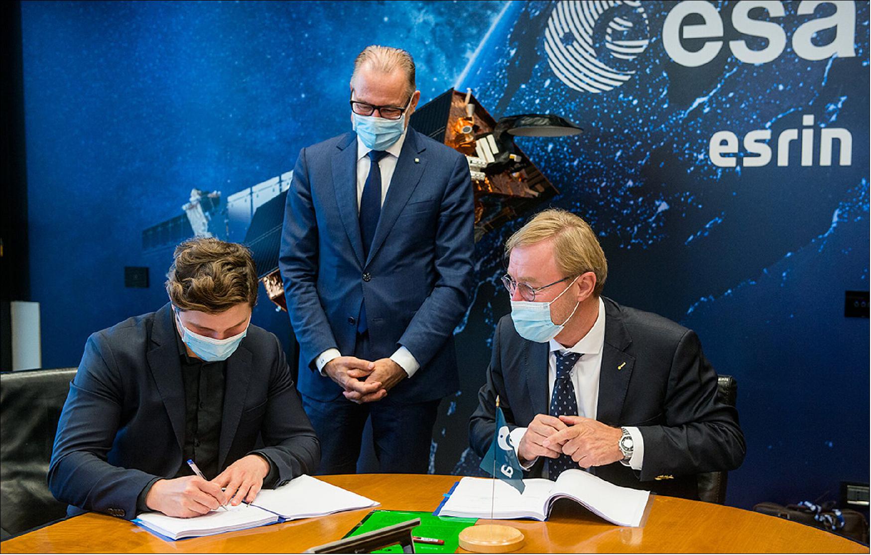
• October 12, 2021: The European Space Agency (ESA) has signed a contract with ICEYE during ESA’s Φ-week, bringing the company's constellation of small Synthetic Aperture Radar (SAR) satellites into the Copernicus environmental monitoring program. ICEYE operates a commercial constellation of SAR satellites, with 14 launched so far and plans to expand to 18 satellites by mid-2022. These satellites provide high-resolution Earth observation data for various applications, including monitoring floods, mining activities, marine vessel detection, and iceberg monitoring. ICEYE's SAR data will complement existing missions within the Copernicus program, enhancing its capabilities in environmental monitoring and emergency response. 39) 40)
• October 7, 2021: ICEYE has appointed Lisa Wardlaw as Global Head of Insurance Solutions to lead the company's efforts in delivering natural catastrophe data solutions to the insurance industry. ICEYE, which operates the largest synthetic-aperture radar (SAR) constellation in the world, provides actionable insights about natural hazards in near real-time by combining data from spaceborne sensors with auxiliary information sources. Wardlaw brings extensive experience in strategy, innovation, and digital transformation in the insurance sector, having previously held roles at Zurich Insurance Group and Munich Re. ICEYE's recent efforts include tracking and analyzing flood events globally and launching new SAR satellites to enhance its capabilities.
- Additionally, ICEYE announced the appointment of Daniel Stander as a Senior Advisor. Stander, with a background in risk finance and climate risk management, will work with ICEYE to bridge the data gap and provide timely access to critical hazard and damage data for insurers and reinsurers. Both appointments reflect ICEYE's commitment to transforming the insurance value chain through innovative solutions and expertise in monitoring catastrophic events. 41)

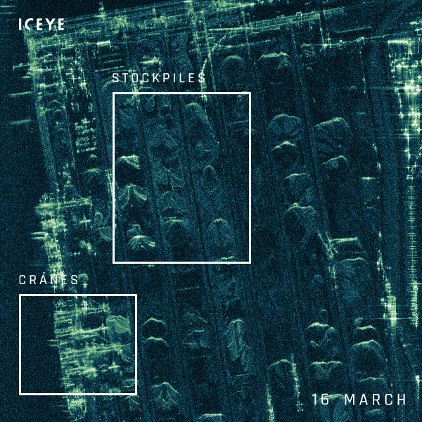
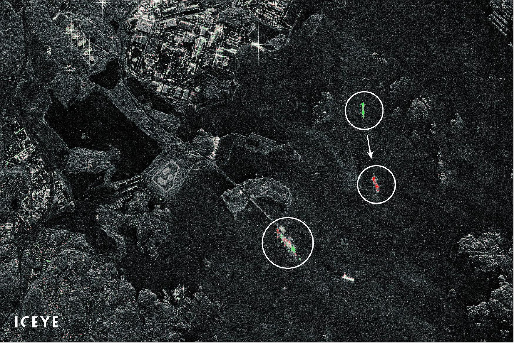
• July 6, 2021: ICEYE has achieved a world-first capability called Daily Coherent Ground Track Repeat (GTR) imaging with its radar satellites. This achievement allows for the detection of detailed changes on the ground every 24 hours, making it possible to monitor activities, patterns of life, infrastructure integrity, and more. ICEYE provides the most frequent coherent radar satellite data coverage to its selected initial customers, with plans to expand availability in 2022. The Daily Coherent GTR capability relies on the exact similarity, or coherence, between two radar satellite images taken at different times. By analyzing the coherence, ICEYE's technology can detect changes such as vehicles moving, stockpile adjustments, or deforestation. This achievement is a result of precise orbit adjustments of ICEYE's satellites, ensuring the same locations on Earth are imaged from the same orbit placement every day. The capability offers applications in fields like port monitoring, construction site tracking, and infrastructure management. It represents a significant advancement in persistent monitoring with radar satellites, providing detailed insights into daily changes at selected locations. 42)
• July 1, 2021: ICEYE has successfully launched four Synthetic Aperture Radar (SAR) satellites on a SpaceX Falcon 9 rideshare mission via Exolaunch. Three of these satellites will be added to the ICEYE constellation, while the fourth will serve as a demonstration mission for the company's next-generation spacecraft. ICEYE now operates the world's largest constellation of agile SAR satellites, allowing for persistent monitoring with very short revisit times, and its expansion and innovation in radar satellite imaging continue to enhance its capabilities for persistent monitoring and serving a global customer base. 15)
• June 23, 2021: ICEYE has appointed Makoto Higashi as the General Manager for its business operations in Japan. With over 40 years of experience in business operations, including roles as CEO and President of Japan Space Imaging Corporation and GM, GEOINT, at Hitachi Ltd., Mr. Higashi will lead ICEYE's efforts in serving the Japanese government and local commercial organizations. ICEYE plans to open an office in Tokyo and expand to a 10-person team in Japan within the first year, focusing on providing crucial radar satellite data services to the Japanese satellite data market. The company's advanced technology, including SAR image acquisition and near real-time data analysis, is already serving clients like Tokio Marine & Nichido Fire Insurance in Japan, enabling faster claims processing after natural catastrophes. 43)
• June 10, 2021: ICEYE's radar satellite data has been fully integrated into the European Space Agency's (ESA) Third Party Missions (TPM) program, providing access to the data for researchers and Earth Observation (EO) application developers. Through this program, ESA offers free access to ICEYE's SAR data for scientific, research, and pre-operational EO applications. ICEYE is the first New Space organization to provide data in all radar imaging modes through the program, including Spot, Strip, and Scan. This integration further enhances the resources available to the global Earth observation community, enabling access to a wide range of SAR imagery for various applications. 44)
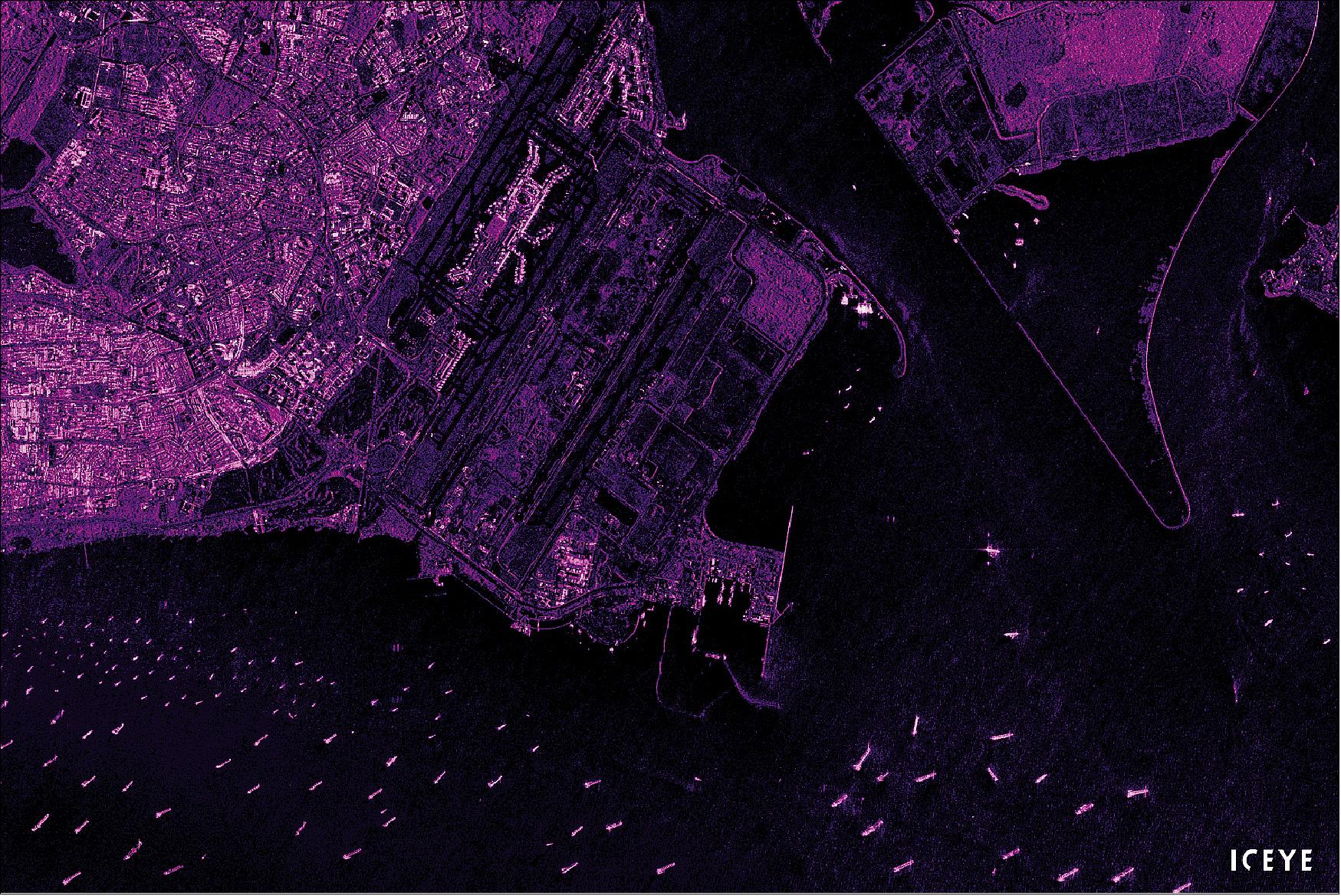
• May 10, 2021: ICEYE has commercially introduced wide-area imaging capabilities covering up to 10,000 square kilometers with its SAR (Synthetic Aperture Radar) satellite constellation. This achievement allows ICEYE to provide the world's most comprehensive persistent monitoring capabilities for both land and sea applications, with a coverage area up to 100 times larger than its closest competitors. This wide-area Scan mode imaging is particularly valuable for maritime use cases, enabling authorities to monitor large sea areas for purposes like maritime safety and national security, day or night, and even through cloud cover. 45)

• April 15, 2021: ICEYE has opened a new manufacturing facility in Irvine, California, marking a significant expansion of the company's presence in the United States. This facility will be responsible for the production of multiple spacecraft concurrently, along with housing a research and development lab, offices, and customer engagement spaces. The Irvine location will also serve as a Mission Operations Center for monitoring and operating ICEYE's U.S. licensed spacecraft. This expansion aligns with ICEYE's growth and the rising demand for its services, and the company is actively hiring personnel with expertise in various fields to support its operations. 46)
• March 31, 2021: ICEYE has reported $50 million in signed contracts for its radar satellite imaging services, solutions, and satellite missions in the past year, marking nearly a tenfold growth from the previous year. The company's real-time Earth observation capabilities are transforming various industries by providing critical insights into ongoing global events. To meet the growing demand for data, ICEYE plans to launch ten new satellite missions in 2021, exceeding its initial forecasts. This growth is indicative of ICEYE's position as a leader in the SAR data and solutions market, with a focus on real-time Earth observation. 47)
• March 2, 2021: ICEYE has formed a strategic partnership with Swiss Re, one of the world's leading reinsurance and insurance providers, to enhance flood risk management, disaster response, and claims processing worldwide. This collaboration will combine ICEYE's flood monitoring expertise with Swiss Re's risk knowledge to provide tailored solutions and early warning systems. Using ICEYE's radar satellite imaging capabilities, the partnership will offer near real-time flood monitoring, enabling Swiss Re to track and respond to floods globally. Initially focusing on floods, the partnership aims to expand to address other perils such as wildfires, wind, and earthquake damages, providing valuable insights for insurers and reinsurers. 48)
• February 25, 2021: ICEYE has released its first set of images from the three ICEYE SAR satellites launched in January via SpaceX's Transporter-1 mission. Following successful initial operations, the satellites are undergoing calibration before becoming commercially available for customer image orders. ICEYE's radar satellite imaging offers persistent monitoring capabilities, enabling observations day and night, even through cloud cover. As the constellation continues to expand, ICEYE aims to enhance its target revisit capabilities, providing unmatched monitoring capabilities for customers. 49)
• January 25, 2021: ICEYE has successfully launched three SAR (Synthetic Aperture Radar) satellites on SpaceX's Falcon 9 rideshare mission via EXOLAUNCH. These launches bring ICEYE's total satellite missions to 10, including both commercial and dedicated customer missions. The satellites are currently undergoing commissioning after successful early operations procedures. With these additional satellites, ICEYE operates the world's largest and most agile SAR satellite constellation, providing global access and persistent monitoring capabilities. This expansion enhances ICEYE's ability to provide frequent and reliable imaging for various applications, such as border security, flood monitoring, and oil spill detection, regardless of weather or time of day. The company plans to launch at least eight more satellites in the coming year. 14)
• October 13, 2020: ICEYE has made its radar satellite imagery archive accessible to the public, offering nearly 18,000 images taken between mid-2019 and the present. The ICEYE Public Archive includes radar imagery in various modes and is intended for non-commercial use. It provides a unique view of the world, allowing users to explore radar satellite imaging data. The archive can be downloaded and opened in Geographic Information System (GIS) programs like Google Earth Pro or QGIS. While the archive does not contain ICEYE's full catalog of imagery, it offers valuable insights for decision-makers, researchers, and Earth observation enthusiasts. 51)

• July 8, 2020: ICEYE is making its synthetic-aperture radar (SAR) satellite data available for assessment through ESA's Earthnet Third Party Mission (TPM). This program enables the collection and distribution of data from non-ESA satellite missions for international Principal Investigators to use for research and application development. ESA will facilitate the assessment of ICEYE's data through an Announcement of Opportunity process, open to international Principal Investigators. This collaboration enhances access to SAR data for research and development within the Earth observation community and supports global cooperation between space agencies and companies. 52)
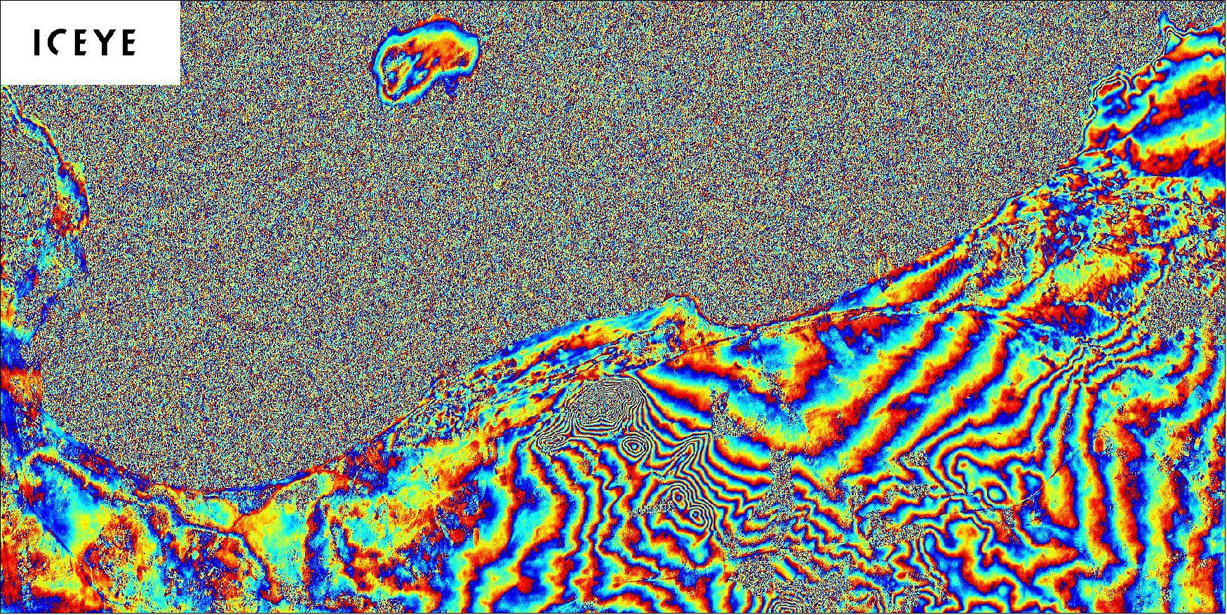
• May 6, 2020: With an actively maintained 18-day repeat ground track worldwide, ICEYE has demonstrated a new radar satellite imaging capability from its current radar satellite constellation. This capability allows ICEYE to detect millimeter-scale surface movements in the vertical direction between two or more SAR images, enabling applications like monitoring underground constructions, analyzing ground deformations after earthquakes, and more. ICEYE's small SAR satellites are equipped with electric propulsion systems, which help maintain the precise satellite orbits required for interferometry. This development opens up new possibilities for change detection and 3D data analysis using SAR satellite technology. 53)
• March 26, 2020: ICEYE has unveiled its latest Synthetic Aperture Radar (SAR) imaging capability, which achieves a resolution of 25 cm with its current commercial SAR satellite constellation. This resolution is equivalent to that provided by larger, conventional commercial SAR satellites. ICEYE initially launched its first SAR satellite in January 2018, achieving 10 x 10 meter resolution data capabilities. This development opens up new possibilities for high-resolution Earth observation and data analysis using SAR technology. 54)
• March 9, 2020: ICEYE has unveiled a new in-orbit demonstration showcasing its capability to create SAR (Synthetic Aperture Radar) videos from its current satellite constellation. This innovation, presented at Satellite 2020 in Washington, DC, allows ICEYE to analyze movement from a single satellite pass. To achieve this, the company focuses its imaging on a precise location for at least 20 seconds during a satellite pass and processes the acquired data into high-resolution frames, creating SAR videos. These videos can detect various types of movement, from vessels near a port to airplanes at an airport, offering advanced radar image analysis tools for data users and decision-makers. 55)
• February 13, 2020: ICEYE has ventured into the U.S. market with the opening of an office in California's San Francisco Bay Area. Responding to strong demand for its synthetic-aperture radar (SAR) satellite data, ICEYE aims to provide top-notch service to its American customers, considering options like establishing a full manufacturing chain in the U.S. ICEYE's SAR technology has gained recognition for its cost-effectiveness and utility in remote sensing. Mark Matossian, a veteran of the aerospace industry with experience at Google's Terra Bella, will head ICEYE U.S., further enhancing the company's ability to cater to the U.S. market's growing appetite for SAR satellite data. 56)
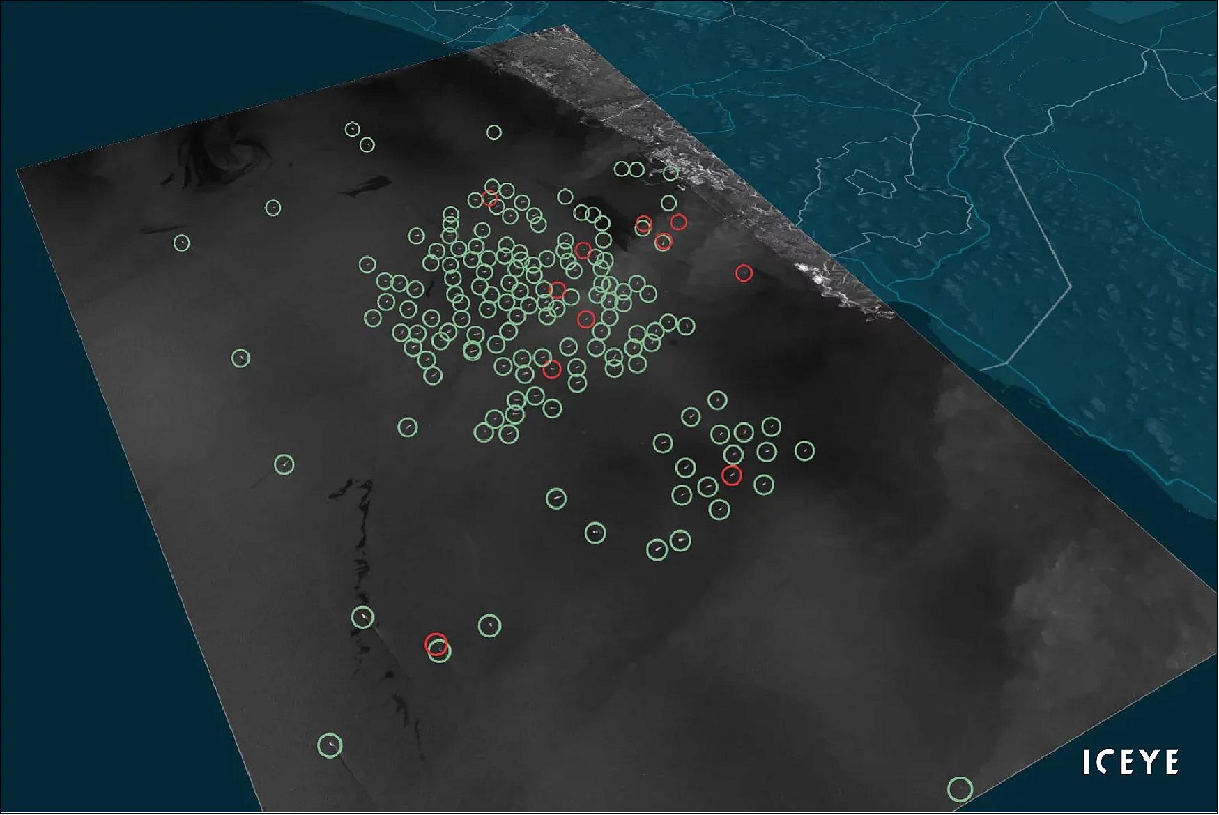
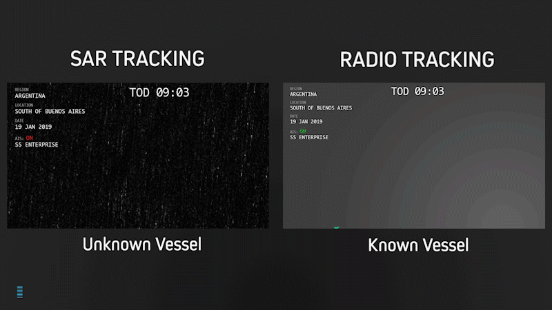
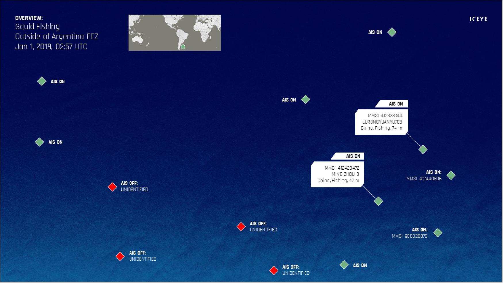
• January 20, 2020: ICEYE has introduced its Dark Vessel Detection solution, catering to the needs of governmental maritime security agencies globally. The solution combines Synthetic Aperture Radar (SAR) satellite data with Automatic Identification System (AIS) data from vessels, enabling governments to monitor their Exclusive Economic Zones (EEZs) efficiently regardless of the time of day or weather conditions, even in the presence of cloud cover. This innovative service aids authorities in combating illegal activities such as transshipment of goods, illegal fishing, and drug and human trafficking by providing reliable location information and radar satellite images of vessels, even when AIS transponders are switched off. 57)
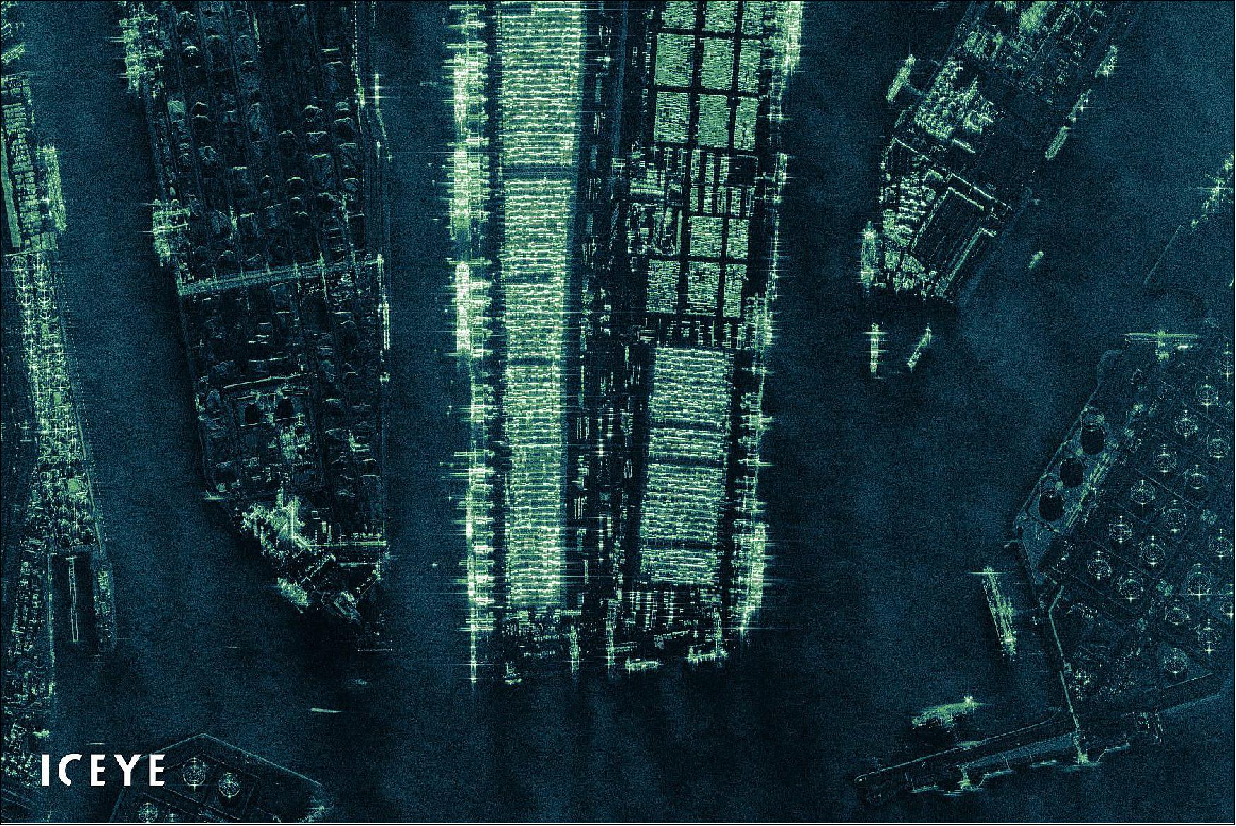
• November 6, 2019: ICEYE has signed a Memorandum of Understanding (MOU) with RS Metrics, a Stamford-based company, to offer satellite Synthetic Aperture Radar (SAR) data and analysis for RS Metrics' "SAR Metal Signals" product. This innovative product will provide the commodities market with the world's first global SAR-based iron ore inventories dataset, featuring daily updates. ICEYE's growing constellation of radar imaging satellites uniquely positions it for remote sensing of iron ore stockpiles, allowing for a comprehensive view of the global iron ore supply chain. Under this partnership, ICEYE will supply multi-angle SAR imaging and iron ore stockpile analysis to RS Metrics, which will, in turn, offer insights into supply chain disruptions, trends, and valuable information for predicting commodities and dry bulk price fluctuations. 58)
• October 16, 2019: ICEYE has announced that its Spotlight imaging mode, which allows for 1-meter radar imaging resolution from its satellite constellation, is now available to customers worldwide. This technology achievement and milestone are significant, as there are very few comparable services available globally. ICEYE is currently the only organization providing this capability as a commercial service from such small SAR microsatellites. High-resolution radar imagery is invaluable for distinguishing small objects and enhancing the classification of larger ones. It has applications in volume monitoring, vehicle count tracking, property damage assessment, and oil transshipment monitoring. This advancement is expected to have a significant impact on sectors like commodities, offering detailed location tracking and competitive advantages to users. 59)
• September 25, 2019: ICEYE and KSAT (Kongsberg Satellite Services) have signed an extended cooperation agreement to offer Near Real-Time (NRT) synthetic aperture radar (SAR) data services to government and commercial clients. This agreement involves further data procurement and prolonged operation of ICEYE's NRT SAR processor within the KSAT Ground Network, ensuring swift data delivery and value-added products for customers. The collaboration allows for streaming satellite data directly to ICEYE's SAR processor on KSAT's local infrastructure, enabling immediate information extraction from the incoming satellite data, resulting in vessel detection results delivered in less than 15 minutes. KSAT has incorporated the ICEYE SAR processor for direct downlink capabilities, offering customers enhanced access to ICEYE SAR satellite constellation data, with scalability for future data volume increases. 60)
• September 12, 2019: ICEYE has completed the initial commissioning of its two SAR satellites launched in July 2019 and made them available for customer data orders. With these additions, ICEYE now offers standardized commercial imaging access from three SAR satellite units and plans to launch two more by the end of 2019. The company aims to increase global commercial availability and coverage through its constellation, enabling very frequent imaging opportunities for individual locations, with an average of only hours between imaging opportunities. 61)
• August 9, 2019: ICEYE has achieved better-than-1-meter resolution imagery from its SAR (Synthetic Aperture Radar) satellites that weigh under 100 kg. This breakthrough in radar satellite imaging demonstrates ICEYE's commitment to pushing the boundaries of small satellite SAR technology. The company continues to launch new satellites and optimize its imaging capabilities to provide reliable and timely imagery to both commercial and government customers, regardless of cloud cover. 62)
• July 5, 2019: ICEYE today confirmed that the simultaneous launch of two new ICE SAR satellites has been successful. The satellites were launched on a rideshare mission of Roscosmos managed by Exolaunch, a Berlin-based company, on July 05 2019 at 05:41 UTC. Communications with both SAR satellites have been established, and the procedure for commissioning both units for commercially available radar imaging has begun. With these units, ICEYE continues to grow its in-orbit capacity that is currently available for both government and commercial SAR data users. 63)
• June 7, 2019: ICEYE and Kongsberg Satellite Services (KSAT) have teamed up to offer full SAR Ground Segment services to ICEYE SAR satellite constellation customers. This collaboration enables a significant reduction in SAR image delivery timelines, with the possibility of image acquisition to processed SAR image delivery within as short as 15 minutes for global government customers. This partnership addresses the need for more rapid access to SAR imagery, which is crucial for various applications, including maritime situational awareness, vessel detection, oil spill monitoring, and ice monitoring. 64)
• July 5, 2019: ICEYE has successfully established communications with both SAR satellites, ICEYE-X4 and ICEYE-X5, and has initiated the commissioning procedure for these units to provide commercially available radar imaging. ICEYE's rapid development and launch process allows for faster access to SAR data for both government and commercial users, contributing to the company's growing in-orbit capacity (Ref. 7).
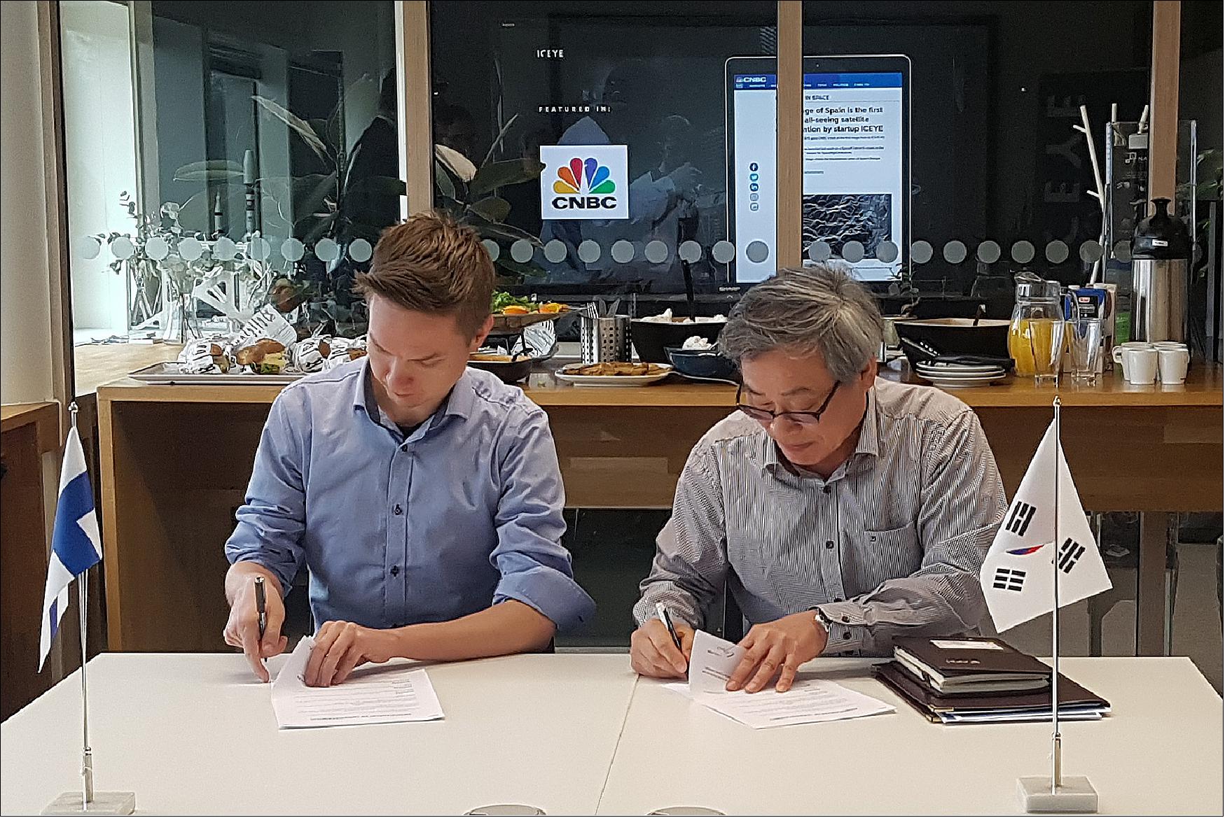
• May 15, 2019: Asia Pacific Satellite Inc. (APSI) and ICEYE have signed a memorandum of understanding to collaborate in supporting the South Korean New Space market. APSI will supply ICEYE's SAR imagery in South Korea and offer mutual support to deliver radar imaging-related satellite solutions for the South Korean market. ICEYE continues to expand its SAR satellite constellation with the goal of launching up to five more satellites in 2019, providing cost-effective and high-resolution SAR imagery. APSI, a provider of equipment and services for South Korean government programs, will leverage ICEYE's technology to enhance its offerings to government and commercial customers in the country. 65)
• January 22, 2019: ICEYE and Spire Global have announced a technology partnership to detect dark vessels and illegal activities at sea. This collaborative effort will combine Spire's Satellite AIS (Automatic Identification System) with ICEYE's synthetic aperture radar imaging to provide a new satellite capability for detecting and combating illegal fishing, transshipment, and maritime trafficking within exclusive economic zones. The technology will also improve the accuracy of tracking vessels involved in illegal activities such as arms, drug, and human trafficking. The partnership aims to address economic, environmental, human rights, and security issues associated with illegal fishing and trafficking activities at sea. 66)
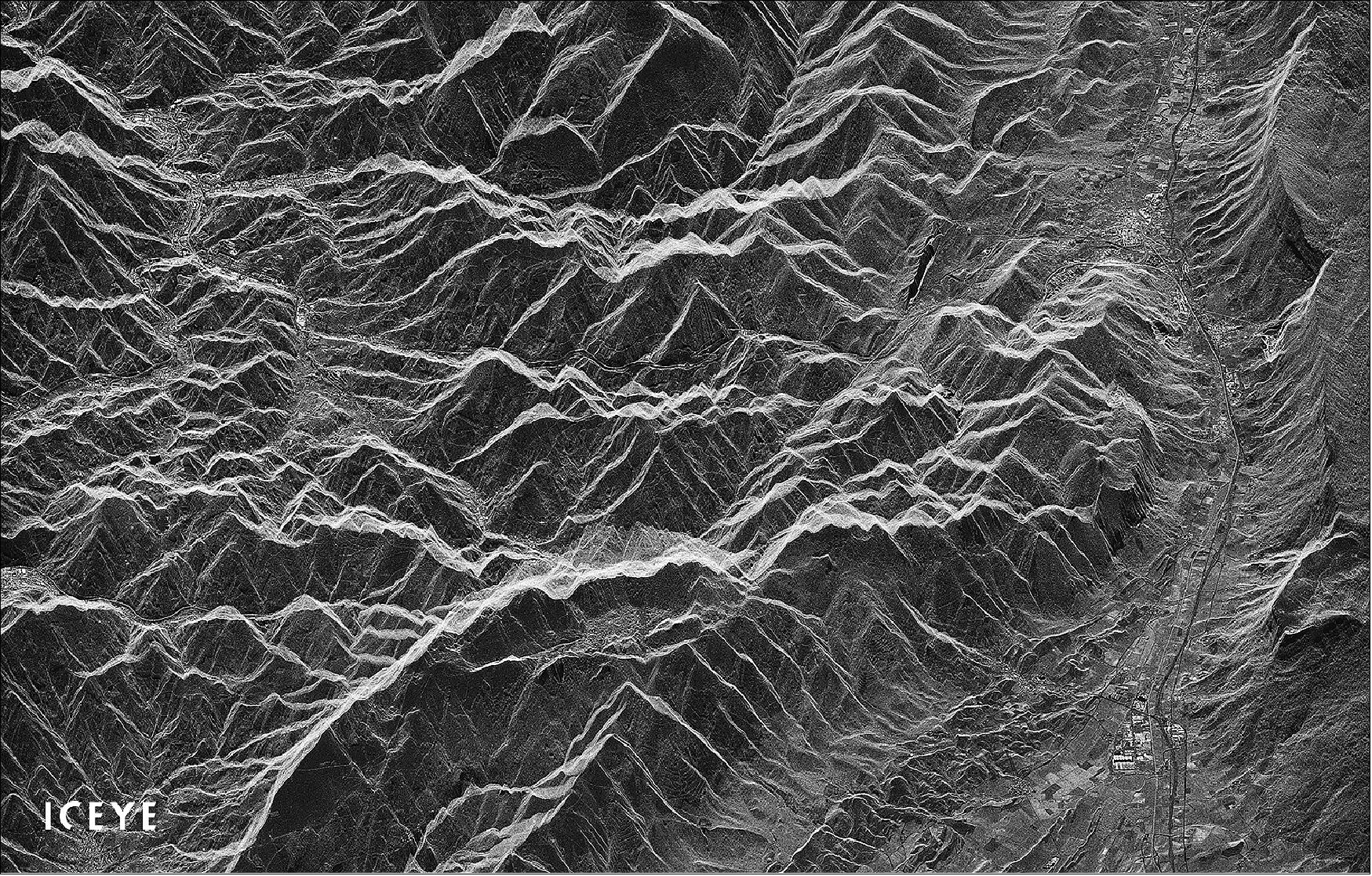
• December 11, 2018: ICEYE has published its first radar image from the ICEYE-X2 satellite, which was launched on Spaceflight's historic SSO-A mission in December 2018. The image captures Natural Parks Aralar and Aizkorri-Aratz in Spain just four days after the satellite's launch. ICEYE-X2 was successfully launched aboard a SpaceX Falcon 9 rocket from Vandenberg Air Force Base in California. This achievement reflects ICEYE's commitment to providing world-leading radar imaging satellites for informed decision-making. 67)
• December 3, 2018: ICEYE's satellite mission, ICEYE-X2, has been successfully launched as part of Spaceflight's SSO-A: SmallSat Express mission aboard a SpaceX Falcon 9 rocket from Vandenberg Air Force Base in California. This marks ICEYE's second satellite successfully placed into orbit within one year, and it's a significant step toward the company's goal of creating the world's largest SAR satellite constellation by the end of 2019. ICEYE-X2 features improvements in in-orbit performance over its predecessor, including enhanced imaging resolution and propulsion for orbital adjustments. The company plans to launch a total of eight additional satellites by the end of 2019. 68)
References
1) ”ICEYE-X2 - Continuous Advancements in Small Satellite SAR,” ICEYE, 2020, URL: https://www.iceye.com/resources/missions/iceye-x2
2) ”ICEYE SAR Product Guide,” Version 2.0, Released 14 August 2019, URL: https://www.iceye.com/hubfs/Downloadables/ICEYE-SAR-Product-Guide-2019.pdf
3) Stephen Clark, ”Spaceflight’s 64-satellite rideshare mission set to last five hours,” Spaceflight Now, 3 December 2018, URL: https://spaceflightnow.com/2018/12/03/spaceflights-64-satellite-rideshare-mission-set-to-last-five-hours/
4) Stephen Clark, ”Spaceflight preps for first launch of unique orbiting satellite deployers,” Spaceflight Now, 23 August 2018, URL: https://spaceflightnow.com/2018/08/23/spaceflight-preps-for-first-launch-of-unique-orbiting-satellite-deployers/
5) Jeff Foust, ”Spaceflight gears up for dedicated Falcon 9 launch,” Space News, 6 August 2018, URL: https://spacenews.com/spaceflight-gears-up-for-dedicated-falcon-9-launch/t).
6) ”Spaceflight - Introducing SSO-A: The smallsat express,” Spaceflight, 3 December 2018, URL: http://spaceflight.com/sso-a/
7) ”ICEYE Reports Successful July 2019 Launch of Two SAR Satellites,” ICEYE, 5 July 20019, URL: https://www.iceye.com/press/press-releases/iceye-reports-successful-july-2019-launch-of-two-sar-satellites
8) Anatoly Zak, ”Soyuz launches fresh Meteor weather watcher and 32 small satellites,” Russian Space Web, 5 July 2019, URL: http://www.russianspaceweb.com/meteor-m2-2.html
9) Anatoly Zak, ”Soyuz delivers its first Gonets-M satellites,” Russian Spaceweb, 28 September 2020, URL: http://www.russianspaceweb.com/gonets-block16.html
10) ”Exolaunch to Deliver the NetSat constellation into Orbit for Würzburg Center for Telematics,” Exolaunch, 15 September 2020, URL: https://web.archive.org/web/20221005115536/https://exolaunch.com/news-block-17.html
11) ”Exolaunch and Glavkosmos announce Soyuz launch campaign for 15 small satellites,” Exolaunch, 17 August 2020, URL: https://web.archive.org/web/20221005112248/https://exolaunch.com/news-block-14.html
12) ”Exolaunch Delivers 15 Small Satellites into Orbit on a Soyuz Rideshare Mission, Deploys 100th Payload into Space,” Exolaunch, 28 September 2020, URL: https://web.archive.org/web/20221005112415/https://exolaunch.com/news-block-19.html
13) ”UK Space Agency: Take-off for UK-built supercomputer nanosatellites,” WiredGov, 29 September 2020, URL: https://www.wired-gov.net/wg/news.nsf/articles/UK+Space+Agency+Takeoff+for+UKbuilt+supercomputer+nanosatellites+29092020154300?open
14) ”ICEYE Establishes World's Top-Performing Persistent Monitoring Satellite Capabilities with Three New SAR Spacecraft Successfully Launched,” ICEYE Press Release, 25 January 2021, URL: https://www.iceye.com/press/press-releases/iceye-establishes-worlds-top-performing-persistent-monitoring-satellite-capabilities-with-three-new-sar-spacecraft-successfully-launched?utm_medium=email&_hsmi=108007477&_hsenc=p2ANqtz-_94ASTpvgB3Y3JKDGHIdrpQMvs_pc8oDhh96kIPBM9pRqlJ3Fecf57VCOLBv1qB3ByCRcgp2szYnGVm6d90Z0kXik2Hw&utm_content=108007477&utm_source=hs_email
15) ”ICEYE Launches Four New Radar Imaging Satellites, Taking a Further Leap Forward in Persistent Monitoring Capabilities,” ICEYE Press Release, 01 July 2021, URL: https://www.iceye.com/press/press-releases/iceye-launches-four-new-radar-imaging-satellites-taking-a-further-leap-forward-in-persistent-monitoring-capabilities
16) ”Transporter-3 Mission,” SpaceX, 13 January 2022, URL: https://www.spacex.com/launches/
17) Jeff Foust, ”SpaceX launches third dedicated smallsat rideshare mission,” SpaceNews, 13 January 2022, URL: https://spacenews.com/spacex-launches-third-dedicated-smallsat-rideshare-mission/
18) ”ICEYE Expands World's Largest SAR Satellite Constellation; launches first U.S. built spacecraft,” ICEYE Press Release, 13 January 2022, URL: https://tinyurl.com/yc4xhzf6
19) ”ICEYE successfully completes its largest satellite launch ever, placing five new SAR satellites into orbit,” ICEYE Press Release, 25 May 2022, URL: https://tinyurl.com/2payfpc5
20) ”ICEYE Supports Insurance Industry and UNDP-led Initiative to Increase Flood Resilience in Ghana,” ICEYE Press Release, 14, July 2022, URL: https://tinyurl.com/535krpue
21) ”ICEYE Launches Geospatial Analysis Platform To Provide Insurers with Instant Flood Impact Analysis,” ICEYE Press Release, 29 June 2022, URL: https://tinyurl.com/8xvbxwpx
22) ”Arturo and ICEYE Team Up to Bring Insurers Near Real-Time Flood and Property Damage Insights,” ICEYE Press Release, 25 May 2022, URL: https://tinyurl.com/5a7kb8p2
23) ”ICEYE Announces Agreement with European Space Agency to Support Copernicus Emergency Services with Flood Insights,” ICEYE Press Release, 23 May 2022, URL: https://tinyurl.com/4zfsxtwu
24) ”Neptune Flood and ICEYE Enter Strategic Collaboration on Flood Insights,” ICEYE Press Release, 9 May 2022, URL: https://tinyurl.com/44p4dse5
25) ”EigenRisk® Adds ICEYE's Flood Insights to Its Global Catastrophe Risk Management Platform,” ICEYE Press Release, 20 April 2022, URL: https://tinyurl.com/49ym6r8r
26) ”ICEYE and Fermat Capital Management Enter Strategic Alliance,” ICEYE Press Release, 15 March 2022, URL: https://tinyurl.com/2dps4xkp
27) ”ICEYE Named to Fast Company’s Annual List of World’s Most Innovative Companies for 2022,” ICEYE Press Release, 8 March 2022, URL: https://www.iceye.com/press/press-releases/iceye-named-to-fast-companys-annual-list-of-worlds-most-innovative-companies-for-2022
28) ”Tokio Marine and ICEYE Announce Strategic Investment and Commercial Collaboration,” ICEYE Press Release, 8 January 2022, URL: https://tinyurl.com/y8mzns96
29) ”ICEYE Raises USD 136M in Series D Funding Round,” ICEYE Press Release, 3 February 2022, URL: https://tinyurl.com/5wtuby2k
30) ”ICEYE US Wins Contract To Participate in National Reconnaissance Office’s Broad Agency Announcement For Commercial Radar,” ICEYE Press Release, 20 January 2022, URL: https://tinyurl.com/bddztzvf
31) ”MDA and ICEYE Sign Agreement to Integrate X-band SAR Satellite Into MDA’s CHORUS™ Constellation,” ICEYE Press Release, 15 December 2021, URL: https://tinyurl.com/bdhrnbpx
32) ”ICEYE Opens New Office and Machine Learning Center of Excellence in Luxembourg,” ICEYE Press Release, 02 December 2021, URL: https://tinyurl.com/ym4s3jmu
33) ”ICEYE and U.S. Army to Pursue Collaborative Research and Development,” ICEYE Press Release, 18 November 2021, URL: https://tinyurl.com/cn4h5r5u
34) ”G42 and ICEYE Sign a Memorandum of Understanding to Collaborate and Develop Advanced SAR Products,” ICEYE Press Release, 17 November 2021, URL: https://tinyurl.com/kfjd9384
35) ”Aon and ICEYE Launch Solution to Better Manage Climate Risks in Japan,” ICEYE Press Release, 17 November 2021, URL: https://tinyurl.com/a9wjkwc4
36) ”ICEYE Announces Flood Hazard Analysis Agreement With McKenzie Intelligence Services,” ICEYE Press Release, 10 November 2021, URL: https://www.iceye.com/press/press-releases/iceye-announces-flood-hazard-analysis-agreement-with-mckenzie-intelligence-services
37) ”ICEYE Announces Contract with NOAA to Tackle Environmental Hazards Often Linked to Climate Change,” ICEYE Press Release, 04 November 2021: URL: https://tinyurl.com/f75f6c6v
38) ”Descartes Underwriting and ICEYE Announce Partnership to Propel Parametric Insurance Product Design with Advanced Flood Observation Technology,” ICEYE Press Release, 20 Oct. 2021, URL: https://tinyurl.com/3mjz87rt
39) ”ICEYE commercial satellites join the EU Copernicus program,” ESA Applications, 12 October 2021, URL: https://www.esa.int/Applications/Observing_the_Earth/Copernicus/ICEYE_commercial_satellites_join_the_EU_Copernicus_programme
40) ”ICEYE Named as a Contributing Mission to Europe’s Copernicus Satellite Imaging Program,” ICEYE Press Release, 12 October 2021, URL: https://is.gd/HeTw5Q
41) ”ICEYE Accelerates Growth In the Insurance Segment with Appointment of Global Head of Insurance Solutions,” ICEYE Press Release, 07 October 2021, URL: https://is.gd/KK4SsX
42) ”ICEYE First in the World to Achieve Revolutionary Daily Coherent Ground Track Repeat,” ICEYE Press Release, 6 July 2021, URL: https://www.iceye.com/press/press-releases/iceye-first-in-the-world-to-achieve-revolutionary-daily-coherent-ground-track-repeat
43) ”ICEYE Expands Satellite Offering in Japan, Makoto Higashi Joins as General Manager for Local Business Operations,” ICEYE Press Release, 23 June 2021, URL: https://www.iceye.com/press/press-releases/iceye-expands-satellite-offering-in-japan-makoto-higashi-joins-as-general-manager-for-local-business-operations
44) ”ICEYE Approved as Full ESA Earthnet Third Party Mission - The Program Opens Access to ICEYE SAR Data for Researchers and Developers,” ICEYE Press Release, 10 June 2021, https://www.iceye.com/press/press-releases/iceye-approved-as-full-esa-earthnet-third-party-mission-the-programme-opens-access-to-iceye-sar-data-for-researchers-and-developers
45) ”ICEYE Introduces the World’s First Wide Area Imaging for Persistent Monitoring with New Space SAR Satellites,” ICEYE Press Release, 10 May 2021, URL: https://www.iceye.com/press/press-releases/iceye-introduces-the-worlds-first-wide-area-imaging-for-persistent-monitoring-with-new-space-sar-satellites
46) ”ICEYE Opens New Spacecraft Production Facility in Irvine, California, Expands U.S. Manufacturing, Research and Customer Operations,” ICEYE Press Release, 15 April 2021, URL: https://www.iceye.com/press/press-releases/iceye-opens-new-spacecraft-production-facility-in-irvine-california-expands-us-manufacturing-research-and-customer-operations
47) ”ICEYE Reports Contracts Valued at $50M in 2020 and Announces New Launches to Meet Growing Demand,” ICEYE Press Release, 31 March 2021, URL: https://www.iceye.com/press/press-releases/iceye-reports-contracts-valued-at-50m-usd-in-2020-and-announces-new-launches-to-meet-growing-demand
48) ”ICEYE Enters Into A Strategic Partnership With Swiss Re Advancing Natural Catastrophe Services With Radar Satellite-Based Flood Monitoring,” ICEYE Press Release, 02 March 2021, URL: https://is.gd/kr7sai
49) ”ICEYE’s 3 Newest Satellites From Late January Launch Return First Radar Images,”ICEYE Press Release, 25 February 2021, URL: https://is.gd/FmEWos
50) ”NGA wants faster access to commercial geospatial data,” SpaceNews, 12 January 2021, URL: https://spacenews.com/nga-wants-faster-access-to-commercial-geospatial-data/
51) ”ICEYE Shares Nearly 18,000 Satellite Image Catalog Under Creative Commons License,” ICEYE Press Release, 13 October 2020, URL: https://tinyurl.com/y37mgl8r
52) ”ICEYE SAR Satellite Imagery Available Through the ESA Earthnet Third Party Mission,” ICEYE Press Release, 08 July 2020, URL: https://www.iceye.com/press/press-releases/iceye-sar-satellite-imagery-available-through-the-esa-earthnet-third-party-mission
53) ”SAR Interferometry Demonstrated with an 18-day Global Repeat by ICEYE,” ICEYE Press Release, 6 May 2020, URL: https://www.iceye.com/press/press-releases/sar-interferometry-demonstrated-with-an-18-day-global-repeat-by-iceye
54) ”ICEYE Unveils 25 cm SAR Imaging Capability with Current SAR Satellite Constellation,” ICEYE Press Release, 26 March 2020, URL: https://tinyurl.com/yx3x7lvv
55) ”ICEYE Demonstrates SAR Video Capability from Current SAR Satellite Constellation,” ICEYE Press Release, 09 March 2020, URL: https://www.iceye.com/press/press-releases/iceye-demonstrates-sar-video-capability-from-current-sar-satellite-constellation
56) Debra Werner, ”Iceye establishes U.S. office, considers U.S. manufacturing,” SpaceNews, 13 February 2020, URL: https://spacenews.com/iceye-us-opens/
57) ”ICEYE Dark Vessel Detection Now Globally Available for Government Organizations,” ICEYE Press Release, 20 January 2020, URL: https://www.iceye.com/press/press-releases/iceye-dark-vessel-detection-now-globally-available-for-government-organizations
58) ”ICEYE and RS Metrics Enter Into Agreement to Provide Unmatched Global Iron Ore Stockpile Monitoring,” ICEYE Press Release, 6 November 2019, URL: https://www.iceye.com/press/press-releases/iceye-and-rs-metrics-enter-into-agreement-to-provide-unmatched-global-iron-ore-stockpile-monitoring
59) ”ICEYE High-Resolution Spotlight Radar Imaging Now Commercially Available,” ICEYE Press Release, 16 October 2019, URL: https://www.iceye.com/press/press-releases/iceye-high-resolution-spotlight-radar-imaging-now-commercially-available
60) ”KSAT and ICEYE Extend Partnership with More Radar Satellite Imagery and Faster Data Analysis,” ICEYE Press Release, 25 September 2019, URL: https://www.iceye.com/press/press-releases/ksat-and-iceye-extend-partnership-with-more-radar-satellite-imagery-and-faster-data-analysis
61) ”Two Recently Launched ICEYE SAR Satellites Commissioned - Added to Commercial Constellation,” ICEYE Press Release, 12 September 2019, URL: https://www.iceye.com/press/press-releases/two-recently-launched-iceye-sar-satellites-commissioned-added-to-commercial-constellation
62) ”ICEYE Releases World-First Under 1-Meter Resolution Radar Imagery from SAR Microsatellites,” ICEYE Press Release, 9 August 2019, URL: https://www.iceye.com/press/press-releases/iceye-releases-first-under-1-meter-resolution-spotlight-radar-imagery-from-small-sar
63) ”ICEYE Reports Successful July 2019 Launch of Two SAR Satellites,” ICEYE, 5 July 2019, URL: https://www.iceye.com/press/press-releases/iceye-reports-successful-july-2019-launch-of-two-sar-satellites
64) ”Breaking the 15 Minutes Barrier from Acquisition to Delivery for SAR imaging,” ICEYE Press Release, 7 June 2019, URL: https://www.iceye.com/press/press-releases/iceye-ksat-announce-ground-segment-15-minute-tasking-to-processing-sar-image-capabilities
65) ”APSI and ICEYE to Provide South Korean New Space Market with SAR Imaging Solutions,” ICEYE Press Release, 15 May 2019, URL: https://www.iceye.com/press/press-releases/apsi-and-iceye-to-provide-south-korean-new-space-market-with-sar-imaging-solutions
66) ”ICEYE and Spire Join Forces To Enable Global Monitoring Of Dark Vessels At Sea,” ICEYE Press Release, 22 January 2019, URL: https://www.iceye.com/press/press-releases/iceye-spire-join-forces-enable-global-monitoring-dark-vessels-at-sea
67) ”First Radar Image from ICEYE-X2 Published Only A Week After Launch,” ICEYE, 11 December 2018, URL: https://www.iceye.com/press/press-releases/first-radar-image-from-iceye-x2-published-only-a-week-after-launch
68) ”Launch Success, ICEYE-X2 SAR Satellite Communications Established,” ICEYE Press Release, 3 December 2018, URL: https://www.iceye.com/press/press-releases/launch-success-iceye-x2-sar-satellite-communications-established
69) Wikipedia, ICEYE, URL: https://en.wikipedia.org/wiki/ICEYE
70) ICEYE, “ICEYE’s Four New Generation 3 Satellites Launch with SpaceX’s Transporter-8, Introducing High-Resolution Spot Fine Image Product”, June 13, 2023, URL: https://www.iceye.com/press/press-releases/iceyes-four-new-generation-3-satellites-launch
71) Christiaens, Kris, , “ICEYE”, Future SpaceFlight, December 6, 2022, URL: https://www.futurespaceflight.com/satellites/iceye.html
72) "ICEYE and SATLANTIS Propose New Tandem4EO Constellation, Combining Radar and Optical Imaging for Europe", ICEYE, 14 September 2022, https://www.iceye.com/press/press-releases/iceye-and-satlantis-propose-new-tandem4eo-constellation-combining-radar-and-optical-imaging-for-europe
73) "ICEYE’s Four New Generation 3 Satellites Launch with SpaceX’s Transporter-8, Introducing High-Resolution Spot Fine Image Product", 13 June 2023, https://www.iceye.com/press/press-releases/iceyes-four-new-generation-3-satellites-launch
74) "ICEYE US Receives First Task Order Under NASA Commercial SmallSat Data Acquisition Program", 9 August 2023, https://www.iceye.com/press/press-releases/iceye-us-receives-first-task-order-under-nasa
75) ICEYE, “ICEYE Elevates Its World-Leading Radar Imaging Constellation with Four New Satellites Launched”, November 13, 2023, URL: https://www.iceye.com/press/press-releases/iceye-elevates-its-world-leading-radar-imaging-constellation-with-four-new-satellites-launched
76) ICEYE, “The ICEYE Fleet”, URL: https://sar.iceye.com/5.0/productguide/fleet/
77) Lentz, Denny, “SpaceX Transporter 9 rideshare features new OTV from Tom Mueller’s Impulse Space”, Nasa Space Flight, November 11, 2023, URL: https://www.nasaspaceflight.com/2023/11/transporter-9/
78) ICEYE, “ICEYE strengthens its persistent Earth Observation capabilities with the successful launch of three new satellites.”, March 5, 2024, URL: https://www.iceye.com/press/press-releases/1200-mhz-radar-bandwidth-in-orbit-technology-demonstrator-enhances-iceye-expansive-sar-satellite-constellation
79) Lentz, Denny, “SpaceX launches Transporter-10 rideshare from Vandenberg”, Nasa SpaceFlight, March 4, 2024, URL: https://www.nasaspaceflight.com/2024/03/transporter-10/