MULA (Multispectral Unit for Land Assessment)
EO
Planned
PhilSA
Planned for launch in 2025, the Multispectral Unit for Land Assessment (MULA) is a Filipino Earth Observation mission of the Philippine Space Agency (PhilSA). The mission aims to produce medium resolution multispectral optical imagery for primarily agricultural applications, as well as advance the Filipino national space program.
Quick facts
Overview
| Mission type | EO |
| Agency | PhilSA |
| Mission status | Planned |
Summary
Mission Capabilities
MULA will carry the Surrey Satellite Technology Ltd. (SSTL) TrueColour multispectral optical imager. The produced imagery will have a range of environmental applications including wide area disaster management, land use and land cover change mapping, crop monitoring and forestry management.
Performance Specifications
The TrueColour imager will provide a 5 m Ground Sampling Distance (GSD), with a swath width of 120 km, imaging in 9 bands with a spectral range of 433 nm - 907 nm.
Space and Hardware Components
MULA is based off of the design for SSTL’s TrueColour satellite. The bus has dimensions 0.65 x 0.65 x 0.72 m, with a launch mass of approximately 130 kg. The platform also provides 2 Tb of onboard data storage capacity, with an X-band downlink data rate of up to 1 Gbit/s, an S-band downlink of up to 2.2 Mbit/s, and an S-band uplink data rate of up to 600 kb/s. The platform has a design life of 5-7 years, with orbit average power (OAP) of 35 W, with an 85 W peak.
Overview
The Multispectral Unit for Land Assessment (MULA) is a Filipino Earth observation and national space program development mission, currently being developed by the Advanced Satellite Development and Know-How Transfer for the Philippines (ASP) Project of the Space Technology Applications, Mastery, Innovation, and Advancement (STAMINA4Space) Program and the Philippine Space Agency (PhilSA), in conjunction with industry support from Surrey Satellite Technology Ltd. (SSTL). The mission aims to capture medium resolution optical imagery of the Philippines, for applications predominantly in mapping and agriculture, as well as progress the development of its national space program. 1) 2) 5)
SSTL is providing a Know-How Technology Training Programme to develop the design of the MULA satellite, an Earth Observation small satellite based on SSTL’s new 130 kg TrueColour spacecraft. MULA will provide medium resolution imaging with a wide swath width and will utilise 9 spectral bands for a range of environmental applications including wide area disaster management, land use and land cover change mapping, crop monitoring, and forestry management. The satellite will also fly AIS (Automatic Identification System) and ADS-B (Automatic Dependent Surveillance – Broadcast) payloads for ship and aircraft detection and tracking. The new Know-How Transfer Programme for the Philippines will be the 21st training course delivered by SSTL to international customers over a period of more than 30 years. 5)
TrueColour is an evolution of SSTL’s Disaster Monitoring Constellation (DMC) satellite, and has been innovatively designed to combine a number of colour bands with a 5 m resolution and a wide swath width in a small satellite mass of just 130 kg. TrueColour’s 9 spectral bands have been selected to complement ESA’s Sentinel imaging bands.
In 2019 SSTL and the Filipino Department of Science and Technology- Advanced Science and Technology Institute (DOST-ASTI) signed a contract for the provision of a share of the tasking and data acquisition services from NovaSAR-1, SSTL’s small S-band radar satellite launched in September 2018. That agreement gives DOST-ASTI tasking priorities over the Philippines and the ability to access the raw data directly from the satellite, with a licence to use and share the data with their partners over an initial 5 year period, extendable to the actual lifespan of the satellite 2)
Spacecraft
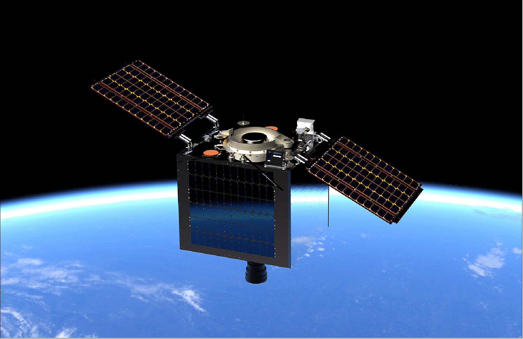
MULA is based off of the design for SSTL’s TrueColour satellite, using the TrueColour imager and an SSTL-X50 bus, shown in Figure 2. The X50 bus offers a highly flexible and cost effective platform, with high speed data handling and storage, ideal for high data volume missions such as MULA. The bus has dimensions 0.65 x 0.65 x 0.72 m, with a launch mass of approximately 130 kg. The X50 platform also provides 2 Tb of onboard data storage capacity, with an X-band downlink data rate of up to 1 Gbit/s, an S-band downlink of up to 2.2 Mbit/s, and an S-band uplink data rate of up to 600 kb/s. The platform has a design life of 5-7 years, with orbit average power (OAP) of 35 W, with an 85 W peak. 3) 7)
Launch
MULA is planned for launch in 2025. 7)
Mission Status
- September 16, 2021: MULA Project Manager Engineer John Leur Labrador gave a detailed presentation of MULA’s technical specifications, applications, and its intended applications, to capture imagery for agricultural applications, such as crop monitoring and harvesting forecasts, as well as recording the environmental effects of industrial activities. 6)
- August 22, 2021: MULA engineers completed the Preliminary Design Review, presenting a detailed design of each subsystem, and conformance to the satellite mission 6)
- April 2021: 42 representatives from the Philippines were awarded Satellite Technology Training course certificates from SSTL 6)
- December 2020: Advanced Satellite Development and Know-How Transfer for the Philippines (ASP) Project begins, with the development of MULA one of its primary objectives. 6)
Sensor Complement
TrueColour Imager
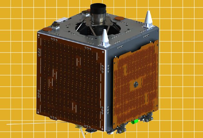
MULA will carry the TrueColour optical imager, designed and developed by SSTL, PhilSA’s industrial partner in the MULA mission. The instrument, seen below in Figure 3, has been described by SSTL as for “Medium spatial resolution and multi-spectral options”, with applications in forestry and agriculture, maritime imagery, mapping and planning, as well as disaster support. The imager has a Ground Sampling Distance of 5 m, with a swath width of 120 km, allowing daily coverage of approximately 73,000 km2. The instrument images in 9 select bands, seen in Table 1.
Band | Spectral Range (nm) |
Aerosol/Coastal | 433-453 |
Blue | 458-523 |
Green | 535-585 |
Red | 640-690 |
Red Edge-1 | 690-720 |
Red Edge-2 | 727-753 |
Red Edge-3 | 769-797 |
Near Infrared-1 | 777-907 |
Near Infrared-2 | 845-885 |
The satellite will also fly AIS (Automatic Identification System) and ADS-B (Automatic Dependent Surveillance – Broadcast) payloads for ship and aircraft detection and tracking. 3) 4) 7)
References
1) Abbey, Ruth. “Marcos bats for dev't of MULA satellite project.” Philippine News Agency, 19 October 2022, https://www.pna.gov.ph/articles/1186536.
2) Dabu, Fred. “PhilSA, UPD, DOST-ASTI aim to launch biggest PH satellite in 2023.” University of the Philippines, 21 June 2021. URL: https://up.edu.ph/philsa-upd-dost-asti-aim-to-launch-biggest-ph-satellite-in-2023/.
3) “Earth Observation satellites from SSTL | Small Satellite supplier.” Surrey Satellite Technology, https://www.sstl.co.uk/what-we-do/earth-observation-spacecraft. Accessed
4) “Philippines “MULA” Earth Observation satellite passes Qualification Status Review at SSTL | Small Satellite supplier.” Surrey Satellite Technology, 9 June 2021, https://www.sstl.co.uk/media-hub/latest-news/2021/philippines-mula%E2%80%9D-earth-observation-satellite-passes-qualification-status-review-at-sstl.
5) “MULA- A Primer on the Philippines Next Generation Satellite” Philippine Space Agency, 16 September 2021, https://web.archive.org/web/20230922052108/https://philsa.gov.ph/books/multispectral-unit-for-land-assessment-a-primer-on-the-philippines-next-generation-satellite/.[e][f]
6) “PhilSA, STAMINA4Space showcase value and capabilities of MULA satellite” Philippine Space Agency, 21 September 2021, https://philsa.gov.ph/news/philsa-stamina4space-showcase-value-and-capabilities-of-mula-satellite/.
7) “PH to launch biggest locally developed satellite in 2025.” CNN Philippines, 20 October 2022, https://web.archive.org/web/20240119092529/https://www.cnnphilippines.com/news/2022/10/20/PH-largest-satellite-mula-reset-launch-2025.html. Accessed 4 May 2023.
8) “UNISEC 2015.” UNISEC Global, http://www.unisec-global.org/pdf/uniglo3/day1_1410-1420.pdf.