Landsat Next
EO
Atmosphere
Ocean
Cloud type, amount and cloud top temperature
Landsat Next (sometimes referred to as Landsat 10) is a planned constellation of three superspectral satellites in continuation of the Landsat series. The mission is a collaboration between NASA (National Aeronautics and Space Administration) and the USGS (United States Geological Survey) with the objective to extend the ability to detect and quantitatively characterise changes on the global land surface at a scale where natural and human-induced causes of land surface change can be detected and differentiated.
Quick facts
Overview
| Mission type | EO |
| Agency | NASA, USGS |
| Mission status | Planned |
| Measurement domain | Atmosphere, Ocean, Land, Snow & Ice |
| Measurement category | Cloud type, amount and cloud top temperature, Ocean colour/biology, Multi-purpose imagery (ocean), Radiation budget, Multi-purpose imagery (land), Surface temperature (land), Vegetation, Albedo and reflectance, Ocean topography/currents, Sea ice cover, edge and thickness, Snow cover, edge and depth, Inland Waters |
| Measurement detailed | Ocean imagery and water leaving spectral radiance, Ocean chlorophyll concentration, Cloud cover, Cloud imagery, Land surface imagery, Fire temperature, Vegetation type, Fire fractional cover, Earth surface albedo, Short-wave Earth surface bi-directional reflectance, Leaf Area Index (LAI), Land cover, Sea-ice cover, Snow cover, Normalized Differential Vegetation Index (NDVI), Iceberg fractional cover, Bathymetry, Fraction of Absorbed PAR (FAPAR), Glacier motion, Glacier cover, Above Ground Biomass (AGB), Active Fire Detection, Long-wave Earth surface emissivity, Permafrost, Cloud mask, Surface Water Extent, Mineral Type |
| Instruments | LandIS |
| Instrument type | Imaging multi-spectral radiometers (vis/IR) |
| CEOS EO Handbook | See Landsat Next summary |
Summary
Mission Capabilities
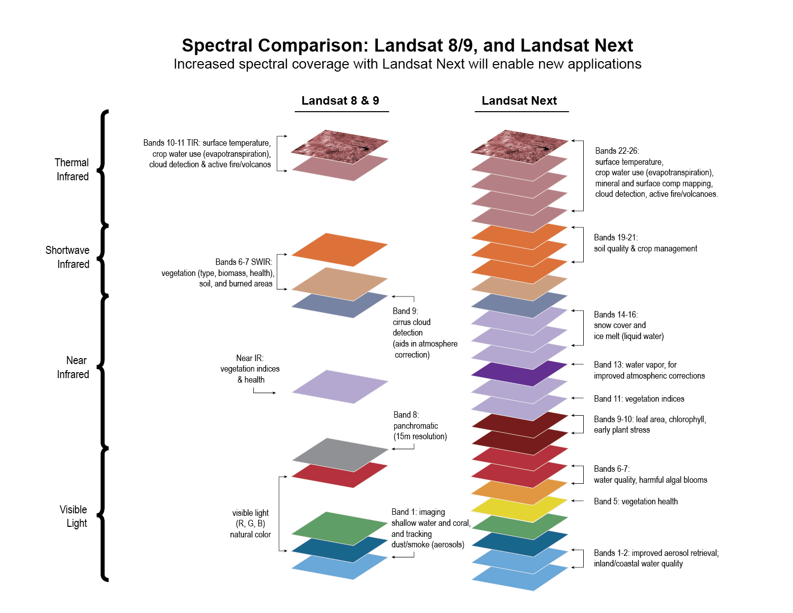
Landsat Next will include the LandIS (Landsat Next Instrument Suite), and will provide more than twice as many spectral bands, with a resolution improved by a factor of two, and with the repeat coverage of Landsat 8 and 9, combined. The constellation will support new emerging applications for Landsat users as well as extend Landsat’s 50-year legacy of uninterrupted Earth observation.
Performance Specifications
LandIS will have imaging capability in 26 spectral bands, which paired with the revisit time of six days, will support applications in fast-changing Earth surface processes like crop growth and natural hazards. Landsat Next’s enhanced spatial resolution will also unlock new applications for water quality, crop production and plant stress, climate and snow dynamics, soil mapping, and other essential climate variables.
Space and Hardware Components
The three identical Landsat Next satellites will be smaller than its predecessors, allowing the launch of the trio constellation together on the same launch vehicle. The orbital configuration of the satellites will support LandIS enhanced imaging capabilities every six days at the equator. The Landsat Next mission has passed Key Decision Point-A authorisation and will continue its development.
Overview
Landsat Next, a joint-agency partnership between NASA and the USGS, is a planned ‘superspectral’ three-satellite constellation to follow on from Landsat 8 and 9. The 26 spectral band constellation will provide enhanced spatial and temporal resolution to support applications in water quality, crop production and plant stress, climate and snow dynamics, soil health, and other essential climate variables. Landsat Next will continue the Landsat Program’s heritage, offering global and repetitive multispectral imagery of the Earth’s surface to fulfill Landsat user needs. On 29 November 2022, NASA and the USGS held a Key Decision-Point A meeting to proceed with the Landsat Next mission. 1) 2)
The collaboration between NASA and the USGS is designed to provide more frequent and finer resolution data of the Earth’s surface. The Landsat series of satellites has continuously produced imagery of the Earth’s surface for over 50 years, allowing researchers and resource managers to track changes in the natural and human-influenced environment. This civilian satellite program was initiated to map, monitor, and manage the Earth’s natural resources and throughout the series’ operation has provided an unbiased and unvarnished history of the planet and its changing conditions. 1)
Landsat Next will continue the Landsat legacy, providing imagery in twice as many spectral bands as the previous generation of missions with twice the resolution improvement. Landsat Next is expected to comprise of three small identical satellites in which data from the constellation would be consistent with that of previous Landsat missions for studies of land cover and use changes over a multi-decadal period. Landsat provides essential data that has applications in monitoring the ecosystems, water quality, land cover and land use change, and an unparalleled data record of the environment and climate change.
New spectral bands were added to Landsat Next’s mission requirements in response to emerging science and user needs. For example, new visible bands will help scientists and resource managers manage water quality by identifying chlorophyll or dissolved organic material in the water, as well as harmful algal blooms. Red edge and shortwave bands will help identify stress in forests or croplands. New near infrared and shortwave bands will provide information about snow and ice surface states, water content and freeze-thaw dynamics in a changing climate. Furthermore, the addition of these spectral bands will eliminate current dependencies on external data sources (e.g., MODIS, ASTER) to apply atmospheric correction to generate Level-2 science products, in turn facilitating the delivery of these products in near real-time.
Landsat heritage spectral bands have also been refined. For example, Landsat 8 and 9’s SWIR2 (Short-Wave Infrared 2) band was subdivided into three bands to advance agricultural management and the impact of crop residues on soil fertility, crop productivity, and carbon sequestration. Landsat Next will also increase the number of thermal infrared bands from two to five, which will provide measures of surface emissivity, improve estimates of surface temperature, and help with mapping minerals. 3)
Landsat Program History
With over 50 years of continuous operation, the Landsat program has offered consistent imagery of the Earth with a current global archive volume of 10.7 million scenes – decades worth of data compiled to explore changes in ecosystems around Earth, from forests to coasts to urban areas. The Landsat Data Distribution Policy was revised in 2008 by the USGS to make available the entire Landsat archive to the world at no cost, creating opportunities for anyone interested in the changing planet.
Continuously providing satellite imagery for over 50 years has been a challenge, since the majority of the satellites have transmitted data well beyond their design lives. Landsat has been relied on for more than half a century and was ranked as a top Earth observation program in terms of societal benefits provided 5) 6).
Landsat is the pioneering land remote sensing satellite program, conceived by USGS (United States Geographical Survey) and developed by National Aeronautical and Space Administration (NASA) in the United States. The primary objective was to monitor Earth’s natural resources via multispectral, high spatial resolution images of solar radiation reflected from Earth’s surface. The first three spacecraft of the series were launched in July 1972, January 1975, and March 1978, respectively, and were decommissioned in January 1978, February 1982, and March 1983, respectively.
Following on from experimental missions (Landsat 1, Landsat 2, and Landsat 3), Landsat 4 and Landsat 5 were the first operational Landsat missions launched in July 1982 and March 1984, respectively. The primary objective was to monitor Earth’s resources via multispectral, high spatial resolution images of solar radiation reflected from Earth’s surface. Landsat 4 was kept in orbit for standby housekeeping until it was decommissioned in June 2001, followed by the decommissioning of Guinness World Record holder Landsat 5 in June 2013. 7)
Developed and owned by Earth Observation Satellite Company (EOSAT), Landsat 6 was planned to continue the Landsat imaging series, however, it failed to achieve orbit during launch in October 1993. As a result, Landsat 4 and 5 operations were continued well beyond their expected operational lifetimes.
Launched in April 1999, Landsat 7 is part of NASA’s Earth Science Enterprise (ESE) program. As a successor of Landsat 6, which failed upon launch, the objective of Landsat 7 was to enhance the medium-resolution multispectral imagery of Earth’s continental surfaces provided by previous Landsat satellites. Although it had an initial design life of seven years, Landsat 7 concluded its primary operations in April 2022 after 23 years of operations.
Landsat 8, launched in February 2013, is the eighth satellite in the Landsat spacecraft series. Originally named the Landsat Data Continuity Mission (LDCM), Landsat 8 needed to ensure the continued acquisition and availability of Landsat-like data beyond the duration of the then-current Landsat missions.
Launched in September 2021, Landsat 9 continues the Landsat program’s goal to monitor, understand, and manage land resources crucial for sustaining human life. Landsat 9 mission objectives include the collection and archival of moderate-resolution multispectral data to be made freely available to worldwide users.
Spacecraft
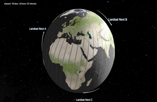
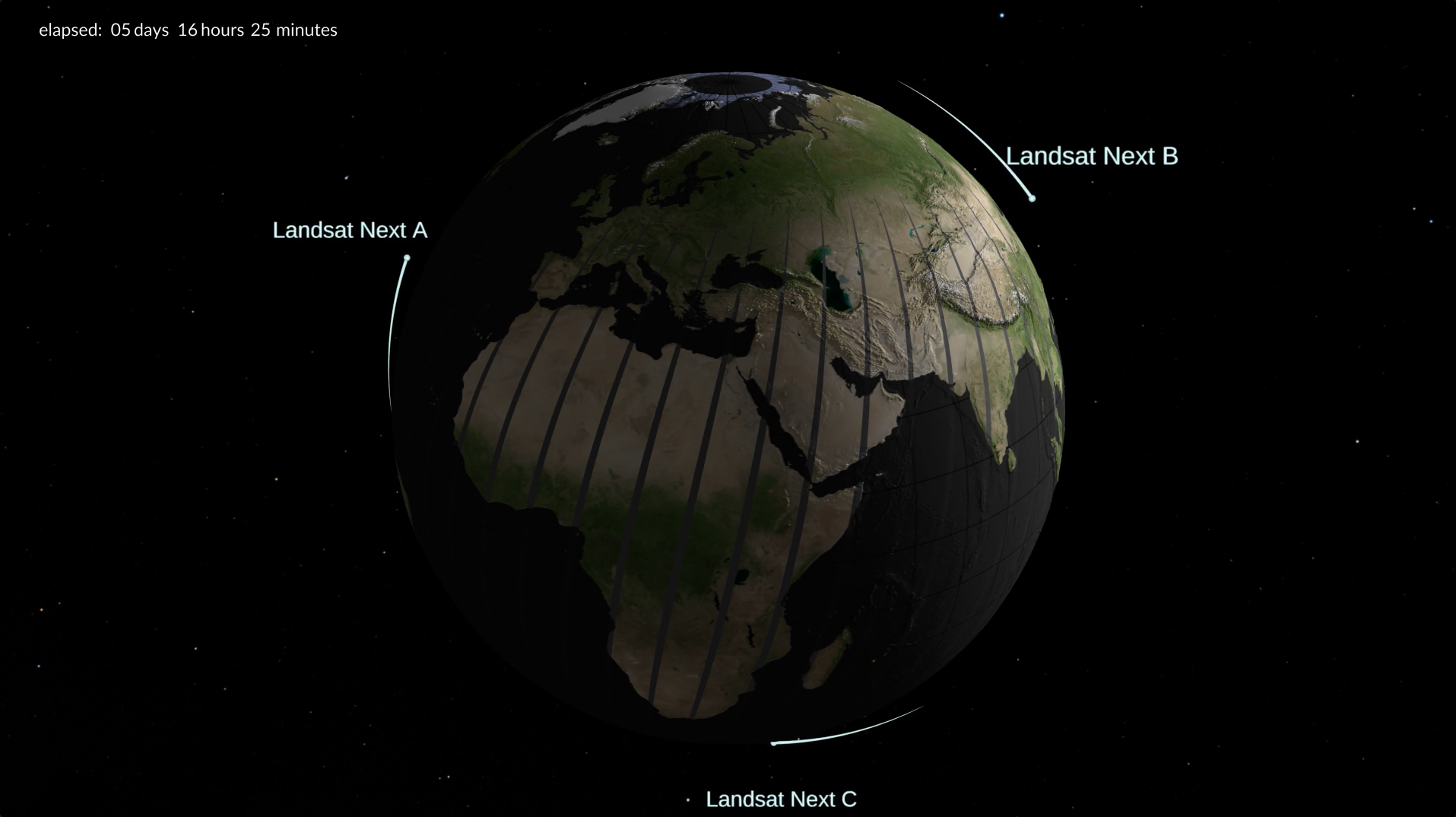
The Landsat Next constellation will consist of three identical observational satellites which will provide an increased temporal revisit for monitoring dynamic land and water surfaces such as vegetation, wildfire burns, reservoirs and waterways, coastal and wetland regions, glaciers, and dynamic ice sheets. The use of a constellation of smaller satellites offers a different option for Landsat as opposed to the series’ conventional singular large satellite bus per mission.
Landsat Next will house 11 refined versions of Landsat’s ‘heritage’ spectral bands, five bands with similar spatial and spectral characteristics to the European Space Agency’s (ESA) Copernicus Sentinel-2 bands to allow easier merging of data products, and ten new spectral bands to support emerging Landsat applications. Landsat Next will collect on average approximately 20 times more data than its predecessor, Landsat 9, and continue to provide free and open data access for all users. 1)
Band Name | Ground Sample Distance (m) | Center Wavelength (nm) | Bandwidth (nm) | Application(s) |
Violet | 60 | 412 | 20 | Improved aerosol retrieval; CDOM from inland/coastal water |
Coastal/Aerosol | 20 | 443 | 20 | Landsat heritage |
Blue | 10 | 490 | 65 | Landsat heritage |
Green | 10 | 560 | 35 | Landsat heritage |
Yellow | 20 | 600 | 30 | Leaf chlorosis, vegetation stress and mapping |
Orange | 20 | 620 | 20 | Phycocyanin detection for Harmful Algal Blooms |
Red 1 | 20 | 650 | 20 | Phycocyanin, chlorophyll |
Red 2 | 10 | 665 | 30 | Landsat heritage |
Red Edge 1 | 20 | 705 | 15 | LAI, Chlorophyll, plant stress (Sentinel-2) |
Red Edge 2 | 20 | 740 | 15 | LAI, Chlorophyll, plant stress (Sentinel-2) |
NIR Broad | 10 | 842 | 115 | 10m NDVI (Sentinel-2) |
NIR 1 | 20 | 865 | 20 | ~Landsat heritage/continuity (note: Sentinel-2 narrower than Landsat 8 and 9) |
Water Vapor | 60 | 945 | 20 | Improved atmospheric correction for Land Surface Temperature, Surface Reflectance (Sentinel-2) |
Liquid Water | 20 | 985 | 20 | Liquid water, water surface state |
Snow/Ice 1 | 20 | 1035 | 20 | Snow grain size for water resources |
Snow/Ice 2 | 20 | 1090 | 20 | Ice absorption, snow grain size |
Cirrus | 60 | 1375 | 30 | Landsat heritage |
SWIR 1 | 10 | 1610 | 90 | Landsat heritage |
SWIR 2a | 20 | 2038 | 25 | Subdivided for cellulose/crop residue measurement (~Landsat heritage) |
SWIR 2b | 20 | 2108 | 40 | Subdivided for cellulose/crop residue measurement (~Landsat heritage) |
SWIR 2c | 20 | 2211 | 40 | Subdivided for cellulose/crop residue measurement (~Landsat heritage) |
TIR 1 | 60 | 8300 | 250 | Mineral and surface composition mapping (ASTER) |
TIR 2 | 60 | 8600 | 350 | Emissivity separation, volcanos (SO2) (MODIS/ASTER) |
TIR 3 | 60 | 9100 | 350 | Mineral and surface composition mapping (ASTER) |
TIR 4 | 60 | 11300 | 550 | Surface temperature (Landsat heritage), carbonates |
TIR 5 | 60 | 12000 | 550 | Surface temperature, snow grain size (Landsat heritage) |
The addition of new spectral bands will respond to evolving scientific and user needs. Visible bands will aid resource managers and scientists to manage water quality by identifying chlorophyll or dissolved organic material in the water, as well as harmful algal blooms. Red edge and shortwave bands will help identify stress in forests or croplands. New near infrared and shortwave bands will provide information about snow and ice surface states, water content and freeze-thaw dynamics in a changing climate. 3)
Launch
Landsat Next is planned for launch in late 2030. The constellation of three satellites will be sent into orbit on the same launch vehicle.
Orbit: The constellation of three observatories is planned to operate in a repeating ground track Sun-synchronous orbit. 3)
Whilst Landsat 9 achieves a repeat period of 16 days, NASA/USGS aims to achieve a combined 6 day repeat cycle for the constellation. This higher temporal frequency provides access to the capture of fast-changing processes like crop growth and natural hazards. 6)
Mission Status
- July 8, 2023: Landsat Next is on the horizon—the new mission will not only ensure continuity of the longest space-based record of Earth’s land surface, it will fundamentally transform the breadth and depth of actionable information freely available to end users.
The Landsat Program is a series of Earth-observing satellite missions jointly managed by NASA and the U.S. Geological Survey (USGS). Landsat satellites have been consistently gathering data about our planet since 1972. They continue to improve and expand this unparalleled record of Earth's changing landscapes for the benefit of all.
References
1) “Landsat Next,” NASA Landsat Science, URL: https://landsat.gsfc.nasa.gov/satellites/landsat-next/
2) “USGS Update to the 36th CEOS Plenary,” Timothy Stryker, 29 November 2022, URL: https://ceos.org/document_management/Meetings/Plenary/36/Presentations/2.11.12_Stryker_USGS_Agency_Report.pptx
3) “Next up to Continue NASA/USGS’s Landsat Legacy,” NASA Landsat Science, 20 December 2022, URL: https://landsat.gsfc.nasa.gov/article/next-up-to-continue-nasa-usgss-landsat-legacy/
4) “Fifty Years of Exploration and Innovation: How Landsat Launched the Remote Sensing Era,” Landsat Legacy, USGS, URL: https://www.usgs.gov/landsat-legacy/fifty-years-exploration-and-innovation-how-landsat-launched-remote-sensing-era
5) National Science and Technology Council report, 2014, URL: https://obamawhitehouse.archives.gov/sites/default/files/microsites/ostp/NSTC/2014_national_plan_for_civil_earth_observations.pdf
6) “Landsat’s Next Chapter,” NASA Goddard, 21 December 2022, URL: https://youtu.be/339KeL29tig
7) “Landsat 5 Sets Guinness World Record For 'Longest Operating Earth Observation Satellite,” NASA, URL: https://www.nasa.gov/mission_pages/landsat/news/landsat5-guinness.html
8) Nasa Goddard youtube channel,“Landsat Next Defined” June 29, 2023, URL: https://www.youtube.com/watch?v=O67fZNW_RBM
9) Friends of Nasa, “Landsat Next Defined: The Future of Earth Observation Satellites | NASA Goddard”, July 8, 2023, URL: https://www.friendsofnasa.org/2023/07/landsat-next-defined-future-of-earth.html